When planning our Big Sur family vacation, we did some digging to find the best kid-friendly hotel and the best family-friendly hikes in the area. Most of the family-friendly hiking trails are located in the Big Sur area California State Parks, so we decided to stay at the Big Sur River Inn at the north end of the Big Sur region and work our way down Highway 1, stopping at all of the State Parks.
We started with Garrapata State Park and worked our way down the Pacific Coast Highway, stopping at Andrew Molera State Park, Pfeiffer Big Sur State Park, and Julia Pfeiffer Burns State Park. Limekiln State Park was the last park on our list before reaching in the Elephant Seal Rookery near San Simeon. It was also one of the coolest stops on our Big Sur Adventure.
Melanie Mabry, a close family friend of ours who is attending Cal Poly, hadn’t yet visited the park, so she drove over with a friend to join us for the morning, which made this adventure even more special!
Limekiln State Park
Adjoining the Ventana Wilderness area of the Los Padres National Forest, Limekiln State Park sits in steepest coastal canyon in the continental US, on the legendary Big Sur coastline, where the Santa Lucia Mountains meet the Pacific Ocean. The park’s more than 700 acres offer 24 campsites, three hiking trails, a redwood forest, a rocky beach, seascapes of the Monterey Bay National Marine Sanctuary, a breathtaking waterfall, and four enormous historic lime kilns.

Hiking In Limekiln State Park
Three hiking trails follow Limekiln Creek’s three tributaries through the redwood forest: Hare Creek Trail, Limekiln Falls Trail, and The Limekiln Trail. All of the trails should be traversed with caution, as the canyon walls are steep and unstable, and there is a lot of poison oak. Also some trails, like the falls trail, will require creek crossings and present terrain challenges.
Hare Creek Trail
The Hare Creek Trail follows its namesake Hare Creek through Hare Canyon through a grove of young redwoods (a little over 100 years old) to a grove of some of the largest and oldest redwood trees in Monterey County.
We skipped the Hare Creek Trail because we wanted to see both the abandoned lime kilns and the waterfall, and we still had other places we wanted to visit that day. Plus, both the Limekiln Trail and the Limekiln Falls Trail start off as the same trail then split.
The Limekiln Trail
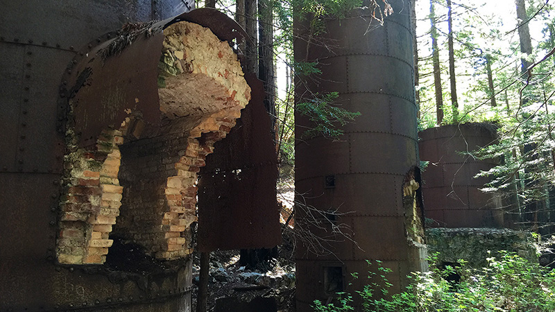
The Limekiln Trail is an easy, 0.5 mile one way, trail that travels through a redwood forest and crosses the west fork of Limekiln Creek over three scenic bridges to the site of four giant, steel and stone lime kilns that once supplied lime used for mortar in San Francisco’s brick buildings.
The abandoned lime kilns are relics from the Rockland Lime and Lumber Company’s 1887-1890 limestone mining operations. The company extracted, processed, and exported thousands of barrels of lime from Limekiln Canyon. They built four huge furnaces at the base of the large talus slope that was eroding from a limestone deposit. Limestone rocks were loaded into the kilns where hot wood fires burned for long periods of time to purify the lime. The lime was then packed in barrels, hauled by wagon to Rockland Landing on the coast, loaded onto ships, and carried to the northern ports for use in concrete and mortar. After only three years, the limestone deposit was practically depleted and the redwood forest was nearly clear cut for lumber and fuel.
When we first saw the lime kilns, I actually think several of us gasped. They are quite amazing and much bigger than I expected. The rusty structures towered above us in the quiet forest; the only surviving trace of mining operations from the past. Standing in the presence of these old, strong structures surrounded by plants and trees, away from the hustle of everyday life was simply amazing. It was like we had stepped back in time.
We are so lucky that these beautiful relics weren’t destroyed. While there are a few small patches of graffiti, the kilns are mostly untouched. We all had a blast exploring the kilns, peeking inside the furnaces, and taking photos.
Limekiln Falls Trail
We hiked to the waterfall last because I had read that our feet would more than likely get wet, and let me just say that this breathtaking waterfall is worth getting your feet wet.
The Limekiln Falls Trail is a more challenging hike along the east fork of Limekiln Creek to a picturesque, 100 foot, fan-shaped waterfall cascading down a limestone wall. It will have you traversing the creek across tree-trunks and at times hiking through the creek water. This Big Sur waterfall has a year round water supply, but the water flow is much heavier and faster after spring rains. Luckily, we visited one week after a huge storm, so the creek water was high, it was flowing fast, and the falls were plentiful.
Now back to the part about your feet getting wet…
We were climbing up narrow, slippery, muddy sections of trail, walking on fallen tree trunks to cross the creek, and enjoying the gorgeous, shady forest. Some sections of the trail were a bit tricky for the kids and we just ended up walking through the creek, but Melanie and her friend traversed tree trunks high above the creek instead.
The trail seems to end below the falls near the creek rapids (where we stopped for the family photo below), but if you cross the creek one more time, you reach the very bottom of the falls (photos of Carter and of Brian and Natalie). You just have to climb up a mud covered pile of boulders using tree trunks to pull yourself up (see the photo of Natalie and Carter climbing down)!
Limekiln Beach
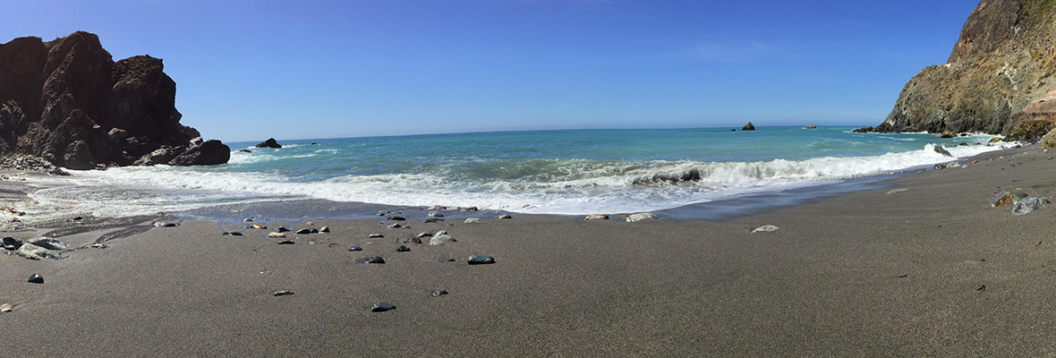
After hiking through Limekiln State Park, we wanted a break and a snack, and what better place to enjoy both than the beach! We grabbed some food and headed down to the rocky Limekiln Beach to enjoy the sun, search for shells, and stick our feet in the water.
Sitting below a bridge on Highway 1, the rock and sand beach stretches across the cove, broken only by the outlet of Limekiln Creek. We hopped from one boulder to another to find a great place to sit and eat and my kids were in heaven — Carter absolutely loves climbing and jumping across the rocks everywhere we go. Natalie looked for pretty shells and Carter stacked rocks, while the adults relaxed.
Before heading back to the car, I tried to cross the creek outlet to get some better photos. BIG mistake. The water is much deeper than it looks, and when the waves crash on the beach, you’re basically doomed. I got soaked. Needless to say, we stayed at the beach a little longer than we planned while I tried to let my butt dry!
Know Before You Go
- Limekiln State Park is located at 63025 Highway 1, Big Sur, CA 93920, 12 miles south of Pfeiffer Big Sur State Park and 39 miles north of Hearst Castle. The park entrance road is at the south end of the bridge over Limekiln Creek.
- Download the Limekiln State Park Brochure
- The park has 24-30 campsites, some in the redwood trees along Limekiln Creek and some near the beach. Each site has a picnic table, a fire ring, and a space for parking.
- Day use access goes from 8:00 am to sunset. There is very little day use parking though, so get there early in the day.
- Paying for day use access into one California state park ($10/car per day) will get you into all California state parks, including Big Sur state parks like Andrew Molera State Park, Garrapata State Park, Pfeiffer Big Sur State Park, Julia Pfeiffer Burns State Park, and Limekiln State Park.
- If hiking to Limekiln Falls, consider bringing an extra pair of tennis shoes or wear water-friendly hiking shoes because your feet may get wet.
Other Nearby Big Sur Attractions
There is nothing like the enormous, historic lime kilns anywhere else in Big Sur, but there is a wide variety of other restaurants, state parks, picnic grounds, stores, bars, and beaches to check out as you drive along the Pacific Coast Highway through the world-renown Big Sur California coastline. There are also tons of family-friendly, outdoor activities to enjoy with the whole family.
When traveling south on Highway 1 from Limekiln State Park, it is approximately:
- 7 miles to Jade Cove
- 8 miles to Sand Dollar Beach
- 10 miles to Willow Creek Picnic Area And Beach
- 19 miles to the Salmon Creek Falls Trailhead
- 23 miles to Ragged Point Inn & Resort
- 40 miles to the Piedras Blancas Elephant Seal Rookery
- 40 miles to Hearst Castle
When traveling north on Highway 1 from LimekilnState Park, it is approximately:
- 15 miles to Julia Pfeiffer Burns State Park
- 24 miles to the Pfeiffer Beach turnouff (Sycamore Canyon Road)
- 25 miles to Pfeiffer Big Sur State Park
- 28 miles to the Big Sur River Inn
- 30 miles to Andrew Molera State Park
- 34 miles to Point Sur State Historic Park
- 42 miles to Garrapata State Park
- 49 miles to Point Lobos State Natural Reserve
- 57 miles to Fisherman’s Wharf and Cannery Row in Monterey, California
- 59 miles to Lovers Point Park in Pacific Grove
- 59 miles to the Point Pinos Lighthouse


