Nestled at the based of the Santa Lucia Mountain Range, Garrapata State Park is an unknown Big Sur treasure hiding in plain sight. Because there is only one small sign, no staff on-site, basically no facilities, and the trailheads are unmarked, many people simply drive right through the park and never even realize it.
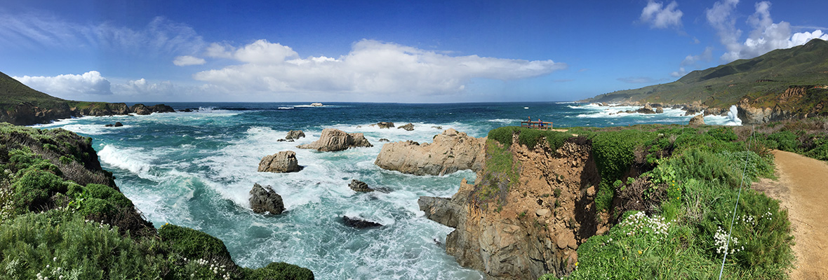
Garrapata State Park is located on the northern end of the Big Sur coast, three miles south of Point Lobos State Natural Reserve. It has just under 3,000 acres of panoramic rocky shoreline, colorful wildflowers, jagged rock formations, steep chaparral-covered hills, deep redwood canyons, challenging hiking trails, and a breathtaking stretch of sandy beach.
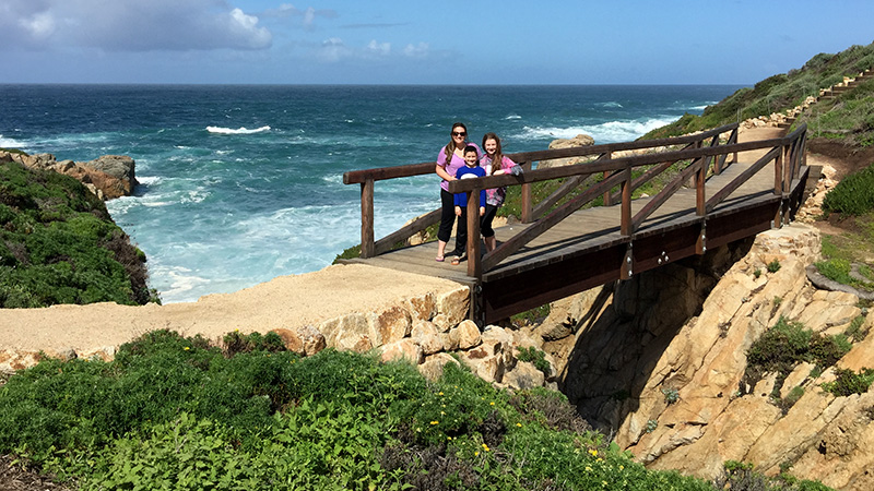
We actually visited Garrapata State Park by accident. It was just before lunch and we were on our way to check in to our hotel, the Big Sur River Inn. But then I saw a gorgeous wooden bridge overlooking the Pacific Ocean and we had to stop to check it out — even it was just for a little bit.
Garrapata Beach
Garrapata Beach is 2.3 miles south of Soberanes Point and can be accessed using either Gate 18 or Gate 19. Now, you can’t actually see Garrapata Beach from the Pacific Coast Highway, and because there are no signs marking the beach’s location along the highway, you’d never know about the 2 miles of magnificent sandy beach that Garrapata State Park has to offer.
If you’re heading to the beach, here are a few things you should know:
- At Gate 18, several trails lead to the beach near Doud Creek.
- At Gate 19, the left-hand trail takes you down stairs to the beach and the right-hand trail continues along the bluff to the Doud Creek Waterfall.
- There are no restrooms at the beach. The only restrooms (inaccessible) are located near Soberanes Point between gates 8 and 9 and between gates 10 and 11.
- The north end of the beach is an unofficial clothing-optional area.
- The surf is often dangerous even for wading, so if you want to swim in the Pacific Ocean, you’re best off going to a beach like Sand Dollar Beach.
- Garrapata State Park is the foggiest location on the Big Sur coast. It is often blanketed in fog even when the other Big Sur locations are clear.
A few unique features of Garrapata Beach include Doud Creek pouring over the bluffs onto the beach, gorgeous spring and summertime wildflowers, and private rocky coves.


Soberanes Family
In 1839, this area was part of Rancho San José y Sur Chiquito, a large Mexican land grant that was later divided. William B. Post acquired two 160-acre parcels, living on the land between 1858 and 1866. In 1867 he sold his land to David Castro, who sold it to Ezequiel Soberanes who operated a prosperous cattle and sheep ranch for 24 years. The Soberanes family also offered their hospitality to other ranchers traveling along the coast to Monterey.
Soberanes Point is named after the Ezequiel Soberanes Rancho.
The two mile, round trip Soberanes Point Trail loops around the Point and has a spur trail that leads to Whale Peak. You can reach the Soberanes Point Trails through Gates 7-10. The trailheads for the popular Soberanes Canyon and Rocky Ridge hiking trails are located at Turnout 13.
The Doud Ranch
Francis Doud, an early Monterey resident, purchased the Soberanes land and other parcels in 1891 to create the Doud Ranch, which ran cattle until the early 1950s. The family’s wood-frame ranch house burned to the ground in the 1960s. The State acquired its first parcel of the property in 1980; Garrapata (Spanish for tick) was classified a state park in 1985.
Doud River is named after Doud Ranch.
Doud Creek Trail
Doud Creek is located in the southern part of Garrapata State Park on both the east and west sides of highway 1. It extends from the eastern edge of the Park boundary to the bluffs where it drops to its terminus on Garrapata Beach.
Only after visiting Garrapata State Park and doing some research did I figure out that the trail we walked was the Doud Creek Trail — and there is serious zero information about this trail online. I found the information from studying maps of the state park’s trail system and finding some old news coverage of the Doud Creek Bridge being built.
We only stopped because I saw the beautiful wooden bridge and the spectacular views beyond it. While you can reach Doud Creek from Gate 18, we entered the park at Gate 19 and followed the trail to the right along the bluffs, visiting once gorgeous scenic lookout after another.
Eventually we reached Doud Creek, an amazing waterfall, and the wooden bridge I had seen from the road. We took in the stunning views of California’s pacific coastline and snapped some photos. Just past the bridge are stairs leading down to the beach, but we decided to save that hike for our next visit. After all, we were starving!
Exploring Garrapata Beach is definitely on my list of to-dos for next time we visit Big Sur.
Know Before You Go
- Download The Garrapata State Park Brochure And Map
- The park is located on Highway 1, 7 miles south Carmel, 18 miles north of Big Sur at 25071-25075 Cabrillo Highway, Carmel-by-the-Sea, CA 93923.
- There is no day use fee, no main entrance, no visitor center or kiosk, and no amenities.
- Dogs are only allowed on Garrapata Beach and must be kept on a leash (6-foot maximum length) at all times.
- All turnouts for Garrapata State Park are located on the west side of Highway 1.
Other Nearby Big Sur Attractions
Garrapata State Park is only one of several California State Parks in the Big Sur region. Others state parks include: Andrew Molera State Park, Pfeiffer Big Sur State Park, Julia Pfeiffer Burns State Park, and Limekiln State Park. There are also several public picnic grounds and hiking trails that leave right from the side of the Pacific Coast Highway.
When traveling south on Highway 1 from Garrapata State Park, it is approximately:
- 8 miles to Point Sur State Historic Park
- 12 miles to Andrew Molera State Park
- 14 miles to the Big Sur River Inn
- 17 miles to Pfeiffer Big Sur State Park
- 18 miles to the Pfeiffer Beach turnouff (Sycamore Canyon Road)
- 27 miles to Julia Pfeiffer Burns State Park
- 42 miles to Limekiln State Park
- 49 miles to Jade Cove
- 50 miles to Sand Dollar Beach
- 52 miles to Willow Creek Picnic Area And Beach
- 61 miles to the Salmon Creek Falls Trailhead
- 65 miles to Ragged Point Inn & Resort
- 82 miles to the Piedras Blancas Elephant Seal Rookery
- 82 miles to Hearst Castle
When traveling north on Highway 1 from Garrapata State Park, it is approximately:
- 7 miles to Point Lobos State Natural Reserve
- 15 miles to Fisherman’s Wharf and Cannery Row in Monterey, California
- 17 miles to Lovers Point Park in Pacific Grove
- 18 miles to the Point Pinos Lighthouse