This year’s Big Sur road trip vacation was by far one of our favorite trips of the year. Not only is the expansive Big Sur coastline a stretch of stunning beauty, with lush green mountains on one side of the Pacific Coast Highway and the sparkling blue Pacific Ocean crashing into the rocky shoreline on the other, it is also packed with awesome family-friendly hikes to beautiful waterfalls and panoramic views.
While we didn’t hit every trail, our Big Sur family hikes did include Salmon Creek Falls and:
- Doud Creek Trail along the coastal bluffs in Garrapata State Park
- Trail Camp Beach Trail and Headlands Trail to Molera Point in Andrew Molera State Park
- Pfeiffer Falls Trail and Valley View Trail in Pfeiffer Big Sur State Park
- McWay Falls Overlook Trail at Julia Pfeiffer Burns State Park
- Limekiln Trail in Limekiln State Park
Finding Salmon Creek Trail
Big Sur is so close to San Louis Obispo that we planned a day to meet up for some hiking with our close family friend Melanie Mabry who is attending Cal Poly. We planned to meet up for the Limekiln Trail hike and she suggested we also join her and a friend for another hike to Salmon Creek Falls further south on Highway 1.
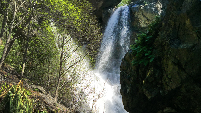
In the Monterey District of Los Padres National Forest, Salmon Creek Falls is a 120 foot waterfall that cascades down a canyon in the Santa Lucia Mountain Range. This waterfall isn’t in a state park, it’s just on the side of the highway and a portion of of this Big Sur waterfall is visible from the highway… but it isn’t very clear about where the trail begins.
The Salmon Creek Trail begins about 3.5 miles north of Ragged Point on the inland side of the Pacific Coast Highway. You’ll know you’re in the right place when you find cars parked in a dirt pullout on the side of road of the most prominent hairpin turn on this stretch of the Pacific Coast Highway.
Hiking Salmon Creek Trail
There is a Salmon Creek Ranger Station, but it is non-operational. Once you park, find the trailhead sign (a brown sign) and follow the trail a short distance to a fork in the trail.
- The full Salmon Creek Trail heads uphill to the right. I read that this trail is about 5 miles, steep and slippery, plus it was covered in Poison Oak, so we skipped it.
- We took the shorter trail to the left to the falls. It ends at a large pile of boulders and two pools formed by the waterfall.
Unlike the other Big Sur waterfalls we saw on our road trip adventure, Salmon Creek Falls begins with two separate cascades that combine together as they plunge over the rocks. The trail isn’t very long and it’s not very difficult.
While you can see Salmon Creek Falls from the boulder pile, there is a giant boulder blocking access to the base of the falls. To get an unobstructed view of the falls, you have to cross the rushing waters of the creek to the other side by using a sketchy looking rope that is hanging down the rock.
We skipped the sketchy rope. We also opted to skip hiking any further uphill on the Salmon Creek Trail because it was almost completely overgrown with Poison Oak, but still had a total blast checking out the waterfall and climbing over and through the large boulders. There were even some rock caves that we all could play in a bit — which was a big hit with the kids.
Know Before You Go
- Located on the inland side on Highway 1, about 3.5 miles north of Ragged Point and 18.5 miles north of the Hearst Castle turnoff, or if heading south, it’s 33.5 miles south of Julia Pfeiffer Burns State Park.
- The out and back hike to this 120 foot waterfall is only about a quarter mile total.
- You’ll have to climb on the boulders to see the falls. It wasn’t a big deal for my kids, but I wouldn’t recommend it for toddler-age kids.
- There are no restrooms, there is poison oak, and trust me, it would be best to wear sturdy shoes — no flip flops.
Other Nearby Big Sur Attractions
Salmon Creek Falls is just one of the many magnificent waterfalls tumbling down the Santa Lucia Mountains along California’s Big Sur coastline. With hundreds of miles of hiking trails, looking out over the sparking blue Pacific Ocean, waves crashing against the rocky shoreline, redwood lined canyons, and lush grassy meadows, Big Sur is a scenic wonderland.
When traveling south on Highway 1 from the Salmon Creek Falls Trailhead, it is:
- 4 miles to Ragged Point Inn & Resort
- 21 miles to the Piedras Blancas Elephant Seal Rookery
- 21 miles to Hearst Castle
When traveling north on Highway 1 from the Salmon Creek Falls Trailhead, it is:
- 9 miles to the Willow Creek Picnic Ground
- 11 miles to Sand Dollar Beach
- 12 mile to Jade Cove
- 19 miles to Limekiln State Park
- 33 miles to Julia Pfeiffer Burns State Park
- 42 miles to the Pfeiffer Beach turnouff (Sycamore Canyon Road)
- 43 miles to Pfeiffer Big Sur State Park
- 46 miles to the Big Sur River Inn
- 48 miles to Andrew Molera State Park
- 52 miles to Point Sur State Historic Park
- 60 miles to Garrapata State Park
- 67 miles to Point Lobos State Natural Reserve
- 75 miles to Fisherman’s Wharf and Cannery Row in Monterey, California
- 77 miles to Lovers Point Park in Pacific Grove
- 77 miles to the Point Pinos Lighthouse


