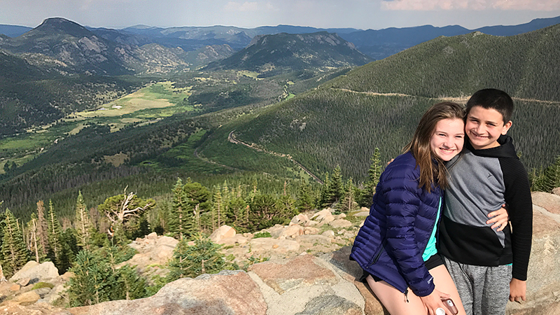
One of the things we love about visiting national parks is how accessible they are. Yes, there are backcountry trails and massively long hikes to push even those in the best shape, but what we love are the scenic drives dotted with scenic overlooks, amazing views, and family-friendly hikes for those who love the outdoors, but maybe aren’t up for an 8+ mile hike. Plus, when we’re visiting national parks, we usually only have a 1-3 days in the park depending on size and we’d rather see and experience as many different things as possible than hike one trail that takes the entire day.
This is why we loved exploring Trail Ridge Road so much! On this one 48 mile drive, we visited the Kawuneeche Visitor Center, Farview Curve Overlook, Medicine Bow Curve Overlook, the Alpine Visitor Center, Gore Range Overlook, Lava Cliffs Overlook, and Rock Cut Overlook, Forest Canyon Overlook, Rainbow Curve Overlook, Many Parks Curve Overlook, and the Beaver Ponds Boardwalk.
After so many high-elevation scenic viewpoints above the treeline, we were excited to drop back down into the lower elevation and stop at Rainbow Curve.
At 10,875 feet elevation, Rainbow Curve Overlook in Rocky Mountain National Park provides fantastic views of Hidden Valley, Horseshoe Park, Alluvial Fan, Fall River and the Beaver Ponds, and several prominent mountain peaks.
Rainbow Curve, enclosed by a low stone wall, sits on the outer edge of a wide switchback on Trail Ridge Road 12.8 miles from the Beaver Meadows Entrance Station. From this vista point, you can see:
- Mount Chapin (12,454)
- Mount Chiquita (13,069)
- Ypsilon Mountain (13,514)
- Mount Fairchild (13,502)
- Hagues Peak (13,560)
- Mommy Mountain (13,425)
- Bighorn Mountain (11,463)
- McGregor Mountain (10,456)
- Deer Mountain (10,013)
But even more interesting than the majestic rocky mountains is everything you can see down below the scenic viewpoint.
Below lies Hidden Valley and Hidden Valley Creek, isolated from Horseshoe Park by a high ridge. Melting glaciers left moraines along each side of Horseshoe Park between 30,000 and 12,000 years ago, and Hidden Valley was blocked off. Now Fall River meanders by the meadows of Sheep Lakes through Horseshoe Park where a glacier once ground its way eastward.
On the north side of Horseshoe Park, you can see a light-colored, 42 acre alluvial fan of rubble — the site of two historic floods.
- On July 15, 1982, Lawn Lake broke through its earthen dam and in a matter of hours, more than 29 million gallons of water carried trees and car-sized boulders down into the valley.
- A second flood in 2013 was caused by unusually heavy rains. This created further erosion along the stream valley, dislodging more trees and boulders and draining into the meadow below.
Thunderstorm Warnings
We visited Rainbow Curve Overlook multiple times during our travels along Trail Ridge Road between Grand Lake and Estes Park, mainly because the first time we stopped a huge thunderstorm was rolling in, the sky was dark, and the view was just crappy.
Luckily, the next day it was sunny and gorgeous and we got to experience the view as it should be.
While we were at the overlook, we began chatting with a friendly ranger who explained that heavy thunderstorms and lightning are common in this area on summer afternoons and it’s not safe for travelers to be unprepared. She told us that in 2014, a lightning strike at Rainbow Curve Overlook killed one man and injured 13 others and the very next day a woman died from a strike while hiking the Ute Crossing Trail above Rainbow Curve. She also shared that a woman was struck by lighting just the day before and was in the hospital!
It was definitely a good reminder to take thunderstorm warnings seriously when you’re in the mountains.
Know Before You Go
- Rainbow Curve Overlook is a scenic viewpoint on Trail Ridge Road in Rocky Mountain National Park. From this vista point at 10,875 feet elevation, you can see stunning mountain peaks, Horseshoe Park, Alluvial Fan, Hidden Valley Creek, and the Beaver Ponds.
- Accessible vault restrooms and free viewfinders are available in the 30ish car parking area.
- Trail Ridge Road is a stretch of US Highway 34 that passes through Rocky Mountain National Park, connecting the town of Grand Lake in Grand County and the town of Estes Park in Larimer County, Colorado.
- Also known as the Beaver Meadow National Scenic Byway, Trail Ridge Road runs from Deer Ridge Junction (US HWY 36 and US HWY 34) on the east side of the park to the Colorado River Trailhead on the western side of the park and snow forces its closure from mid-October to June.
- The two-lane, 48 mile, paved road crosses the Continental Divide at Milner Pass and reaches a maximum elevation of 12,183 feet near Fall River Pass.
- Trail Ridge Road, the highest continuous road in the United States, was added to the National Register of Historic Places in 1984.
- Other things to do on Trail Ridge Road include: the Holzwarth Historic Site, Farview Curve Overlook, Milner Pass and Lake Poudre, Medicine Bow Curve Overlook, the Alpine Visitor Center, Gore Range Overlook, Lava Cliffs Overlook, Rock Cut Overlook, Forest Canyon Overlook, Many Parks Curve Overlook, and the Beaver Ponds Boardwalk.
- Set aside at least a half day to drive Trail Ridge Road — longer if you plan on doing any hiking or sightseeing at one of the many overlooks.


