After taking in the breathtaking views at Farview Curve Overlook, Medicine Bow Curve Overlook, the Alpine Visitor Center, Gore Range Overlook, Lava Cliffs Overlook, and Rock Cut Overlook, we seriously didn’t think the views at Rocky Mountain National Park could get any better.
But boy were we wrong.
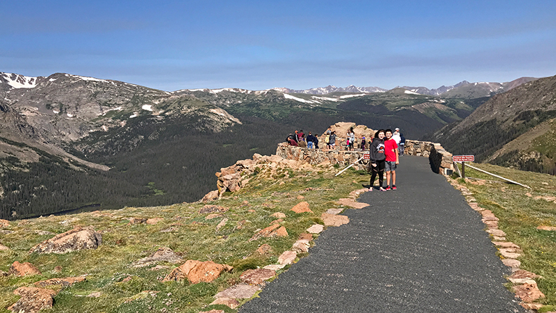
After pulling into the 30ish car parking area halfway between the Alpine Visitor Center and Many Parks Curve, we followed an easy, 0.2 mile, accessible, paved, trail through the alpine tundra to the Forest Canyon Overlook.
At 11,716 feet elevation, Forest Canyon Overlook provides spectacular views of Forest Canyon and the mountains that make up the Continental Divide, as well as yellow bellied marmots, and if you’re lucky, coyote, elk, and sometimes bighorn sheep.
As we walked along the short trail, interpretative signs explained the area’s geology and provided information about the tundra and benches offered a place to sit and enjoy the view a while the kids tried to spot marmots scurrying around the rocks in the tundra. Then at the overlook, it was all about the incredible view.
Forest Canyon Overlook offers one of the best views along Trail Ridge Road in Rocky Mountain National Park. The scenic viewpoint sits on the eastern edge of Forest Canyon, an almost 2,000 foot deep, U-shaped valley that was carved by giant glaciers thousands of years ago. Today Big Thompson River flows through the canyon, which is one of the wildest areas of the park.
Across the valley from the Forest Canyon Overlook sits the Continental Divide, which separates the Atlantic and Pacific watersheds, sending all water to the west toward the Pacific Ocean and all water east toward the Atlantic Ocean. Peaks you can see along the Continental Divide include Mount Ida, Terra Tomah Mountain, and Sprague Mountain. From this scenic vista point, you can also see the blue Gorge Lakes, Hayden Gorge, Hallett Peak, Otis Peak, Stones Peak, and Longs Peak.
Know Before You Go
- Forest Canyon Overlook is one of the best scenic viewpoints on Trail Ridge Road in Rocky Mountain National Park. From this vista point at 11,716 feet elevation, you can see views of Forest Canyon, Mount Ida, Stones Peak, Terra Tomah Mountain, Sprague Mountain, Longs Peak, Hayden Gorge, and the Gorge Lakes.
- The 30ish car parking lot is on the west side of Trail Ridge Road, 6.2 miles from the Alpine Visitor Center and 16.8 miles from the Beaver Meadows Visitor Center.
- An easy, paved, relatively flat, 0.2 mile trail with interpretative signs leads from the parking area west to the overlook perched on the eastern edge of Forest Canyon. This is a great place to spot marmots in the tundra, but be sure to stay on the trail to avoid damaging fragile alpine vegetation.
- Trail Ridge Road is a stretch of US Highway 34 that passes through Rocky Mountain National Park, connecting the town of Grand Lake in Grand County and the town of Estes Park in Larimer County, Colorado.
- Also known as the Beaver Meadow National Scenic Byway, Trail Ridge Road runs from Deer Ridge Junction (US HWY 36 and US HWY 34) on the east side of the park to the Colorado River Trailhead on the western side of the park and snow forces its closure from mid-October to June.
- The two-lane, 48 mile, paved road crosses the Continental Divide at Milner Pass and reaches a maximum elevation of 12,183 feet near Fall River Pass. It is the highest continuous road in the United States, was added to the National Register of Historic Places in 1984.
- Other things to do on Trail Ridge Road include: the Holzwarth Historic Site, Farview Curve Overlook, Milner Pass and Lake Poudre, Medicine Bow Curve Overlook, the Alpine Visitor Center, Gore Range Overlook, Lava Cliffs Overlook, Rock Cut Overlook, Rainbow Curve Overlook, Many Parks Curve Overlook, and the Hidden Valley Beaver Ponds Boardwalk.
- Set aside at least a half day to drive Trail Ridge Road — longer if you plan on doing any hiking or sightseeing at one of the many overlooks.


