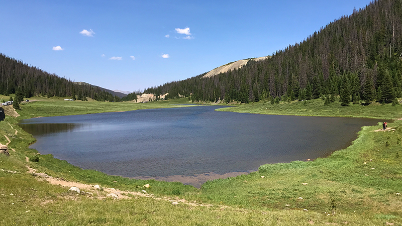
At 10,758 feet elevation, in the Front Range within Rocky Mountain National Park, sits Milner Pass, Poudre Lake, and the Continental Divide.
Milner Pass — named for T.J. Milner, a railroad promoter who first surveyed the area — provides passage over the continental divide for Trail Ridge Road (US Highway 34) between Estes Park and Grand Lake. To the east, you can see Lake Poudre and to the west, you can enjoy a panoramic view of the Never Summer Mountains.
In the Milner Pass parking lot, west of Medicine Bow Curve and the Alpine Visitor Center, you’ll find a sign marking the Continental Divide, which stretches from Alaska almost to Cape Horn where the Atlantic and Pacific plates converge. From here:
- All water on the east side of the Continental Divide, like the Cache la Poudre River, flows to the Mississippi River and then the Atlantic Ocean.
- All water on the west side of the Continental Divide, like Beaver Creek, flows to the Colorado River and then the Pacific Ocean.
East of the Continental Divide is Lake Poudre, the source of the Cache La Poudre River. The alpine lake, also known as Poudre Lake, freezes completely in the winter months, making it a dead lake because no fish can survive.
After hiking to Adams Falls, stopping in the Kawuneeche Visitor Center, and checking out the views at the Farview Curve Overlook, we stopped at Milner Pass and of course, we had to snap a few photos in front of the Continental Divide sign and Lake Poudre.
Also, while in the area we did see some Elk, which was pretty awesome!
Rocky Mountain Weather
We stopped at every scenic overlook and viewpoint along Trail Ridge Road at least twice, some three times. The first day we drove through Rocky Mountain National Park, the skies were grey and cloudy and it was dark. The second day, it was sunny and gorgeous, so we drove from Estes Park to Grand Lake and back and we noticed that the views not only change from the weather, but from the time of day and the position of the sun in the sky.
I definitely recommend that you:
- Come prepared for every type of weather. It’s common, even in the summer, to encounter swift weather changes and rain, thunderstorms, lightning, and wind.
- Give yourself some extra wiggle room in your Rocky Mountain National Park vacation if you can, that way if you get an ikcy weather day, it doesn’t matter.
Look at the pictures of Lake Poudre below and the difference one days makes in the quality of the view! The photo on the left was taken in the afternoon when thunderstorms rolled in and the one on the right was taken the very next day around lunch time.
The Lake Poudre / Milner Pass Trailhead
The Milner Pass Trailhead is also the start of several hiking trails, including a short easy trail around Lake Poudre and:
- The Poudre River Trail is a 10 mile one way, out and back trail, traveling from Lake Poudre along the Cache La Poudre River to the Corral Creek Trail junction, just inside the Roosevelt National Forest.
- The Ute Trail / Milner Pass Trail is a 4.5 mile, out and back trail, traveling from Poudre Lake/Milner Pass to the Alpine Visitor Center that totals 9.0 miles round trip.
- The Mount Ida Trail is a 4.6 mile, out and back trail to the summit of Mount Ida that totals 9.2 miles round trip.
Know Before You Go
- Milner Pass, at 10,758 feet elevation, is a mountain pass on Trail Ridge Road in Rocky Mountain National Park that sits on the continental divide. Here you’ll also find Poudre Lake, the source of the Cache La Poudre River, as well as the trailhead for the Poudre River Trail, an information kiosk, and vault restrooms.
- All the water on the east side of Milner Pass flows to the Mississippi River and the Atlantic Ocean, and the water on the west side flows down the Colorado River and the Pacific Ocean.
- The parking area here isn’t very big and it fills up fast!
- Trail Ridge Road is a stretch of US Highway 34 that passes through Rocky Mountain National Park, connecting the town of Grand Lake in Grand County and the town of Estes Park in Larimer County, Colorado.
- Also known as the Beaver Meadow National Scenic Byway, Trail Ridge Road runs from Deer Ridge Junction (US HWY 36 and US HWY 34) on the east side of the park to the Colorado River Trailhead on the western side of the park and snow forces its closure from mid-October to June.
- The two-lane, 48 mile, paved road reaches a maximum elevation of 12,183 feet near Fall River Pass.
- Trail Ridge Road, the highest continuous road in the United States, was added to the National Register of Historic Places in 1984.
- Other things to do along Trail Ridge Road include: the Holzwarth Historic Site, Farview Curve Overlook, Medicine Bow Curve Overlook, the Alpine Visitor Center, Gore Range Overlook, Lava Cliffs Overlook, Rock Cut Overlook, Forest Canyon Overlook, Rainbow Curve Overlook, Many Parks Curve Overlook, and the Hidden Valley Beaver Ponds Boardwalk.
- Set aside at least a half day to drive Trail Ridge Road — longer if you plan on doing any hiking or sightseeing at one of the many overlooks.


