When planning a family road trip, my husband handles the logistics, reservations, and equipment and vehicle packing, while I handle all of the food, packing the family, and researching and planning our activities — and we’ve got systems for everything so it’s easy, smooth, and nothing is forgotten.
My system for researching and planning activities, includes:
- Mapping the route we’re driving with the places we’re staying.
- Making a giant list of every possible thing there is to do along the route and near each hotel we’ll be at with details about each item.
- Reviewing the list and excluding anything we definitely won’t be doing due to danger, resources/equipment needed, level of difficulty, and lack of amazement/fun.
- Creating a Google map with every activity pinpointed on it so I can visually see what activities are on the route and right off the road (easy/fast), close together (can be done on the same day), or are must do items that are not very convenient.
- Planning a rough outline of the activities we can/will be do each day and researching more details about each one so we are sure to have the “full experience”
- Printing all the details for each activity and organizing them in a binder, in order of activity on the route, so it’s easy to find while we’re in the car and I can access it even if we have no cell signal. It’s also fun to share facts and history about a place we’re about to visit with the family.
When researching things to do in Death Valley, it was pretty easy to group most activities and hikes together by day and proximity to each other, but there was one place I wanted to visit that none of thought we’d have time for — Ubehebe Crater.
Ubehebe Crater is near Scotty’s Castle and on the way to the Teakettle Junction, Racetrack Playa, and Lost Burro Mine. All together that would be an incredible day trip, but Scotty’s Castle is closed for the foreseeable future due to storm damage, and the only road to Teakettle Junction, Racetrack Playa, and Lost Burro Mine is so rough and rugged that special, heavy-duty, off-road tires are required — which we don’t have. So, as a singular activity almost 60 miles away from Furnace Creek, we didn’t think we’d have time to visit Ubehebe.
Thanksgiving day was our fifth and last day exploring Death Valley National Park and the main activity of the day was driving the 27 mile, one-way, twisting dirt Titus Canyon Road and exploring the sights along the way. We kicked off the day checking out the Goldwell Open Air Museum and the Rhyolite Ghost Town just a few miles from the start of the drive, then began our adventure. It took us a little over four hours to finish the Titus Canyon Drive and lucky for us, the road ends about halfway down Scotty’s Castle Road toward Ubehebe.
It was almost three in the afternoon and we were already halfway there, so we couldn’t resist driving out to Ubehebe Crater for sunset.
Visiting Ubehebe Crater
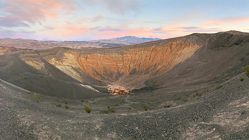
Once we turned off Scotty’s Castle Road onto Ubehebe Crater Road, the desert landscape began to completely change. Volcanic cinders cover much of the area surrounding Ubehebe and it looks much more like Mars than the California desert.
The parking area at Ubehebe isn’t very big but that didn’t matter as it never came close to filling up the entire time we were there. The only thing I can think is that it’s more remote than the other Death Valley attractions so it gets fewer visitors, which is fine with us because we hate loud crowds!
You can see the entire crater right from the parking lot and there is a concrete viewing bench and a couple interpretive displays with more information on the geology and history of the volcano too. But if you want to do some more exploring, there are three trails to choose from:
- Hike Into The Crater: A trail from the parking area leads 600 feet to the bottom of Ubehebe Crater. It’s an easy walk downhill but a much more challenging one hiking back up to the crater rim on loose gravel.
- Follow Little Hebe Trail: A one mile out-and-back trail to Little Hebe.
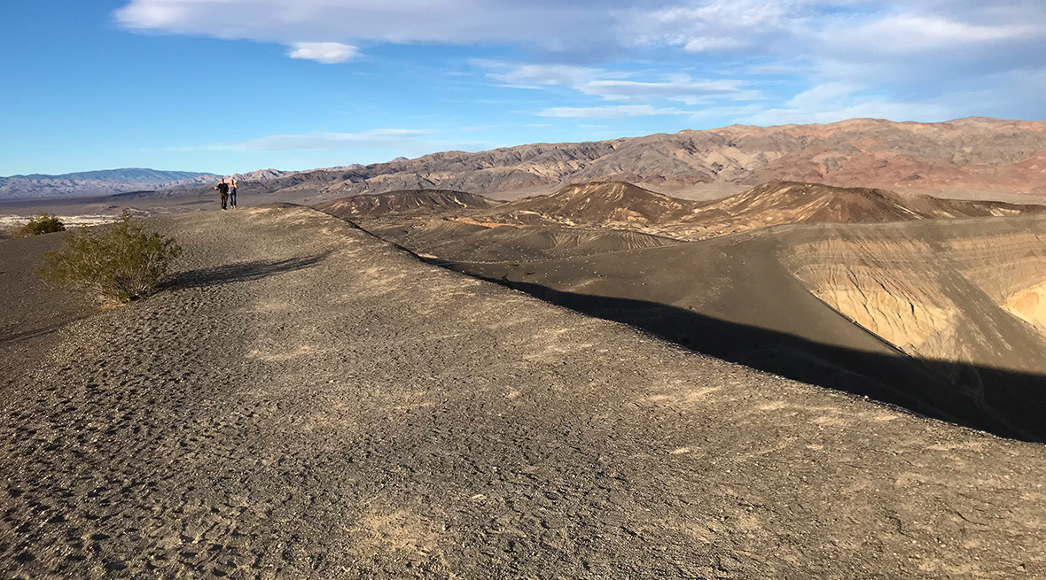
- Walk The Rim Trail: A 1.5 mile loop trail that circles the entire rim of Ubehebe Crater, passing several smaller craters, including Little Hebe. The crater rim and nearby gullies are composed of very loose gravel which makes them unstable and dangerous, so stay on the trail at all times.
It was late and the sun was already setting when we arrived at Ubehebe Crater, so we didn’t hike the entire Rim Trail, but we did follow the Little Hebe Trail… well part of it. We hiked to the top of Ubehebe Crater and were exhausted from a week of adventuring, so Carter is the only one that hiked down into Little Hebe Crater. Also, the trails are made up of deep, loose gravel, so hiking uphill is tough!
After exploring the crater, we waited atop Ubehebe Crater for the sun to set. What’s amazing is that as the sun slowly disappeared, the light across Ubehebe kept changing and it just became more beautiful. Then, the sky lit up with gorgeous, bright, bold colors… it was the perfect ending for the last day of our Thanksgiving vacation in Death Valley National Park.
About Ubehebe Crater
Ubehebe Crater, located at the north tip of the Cottonwood Mountains, is a large, 600 foot deep, half-mile wide volcanic crater. Originally estimated to be 2,000 to 7,000 years old, evidence discovered in 2012 leads some to believe that the crater may be as young as 800 years old.
Ubehebe (YOO-bee-HEE-bee) is the largest of several maar volcanoes in Death Valley. There are clusters of craters to the south and west of Ubehebe and a few right next to Ubehebe! If you walk along the rim of Ubehebe Crater to the west, you’ll pass a few small craters on the way to Little Hebe Crater.
Maar volcanoes are created when rising hot magma rise comes in contact with ground water and turns it to steam. Intense steam pressure builds until the superheated combination of steam and rock explodes, creating a crater like Ubehebe.
The colorful layers in the crater’s east wall mark where the explosion occurred. They are called fanglomerates — alluvial fan deposits that have hardened into rock — and are made up of sandstone and volcanic and metamorphic rocks loosely cemented together by calcite. Water erosion created the deep gullies on the crater’s east side, and the pink and brown mud flat at the bottom of the crater is the site of many short-lived lakes. When Ubehebe exploded, it spewed shattered rock over a six-square-mile area, in some places to depths of 150 feet, which is why the desert landscape around Ubehebe is covered in volcanic rock.
According to the national park website, some people think Ubehebe means big basket, but the Paiute name Ubehebe was first applied to the 5,678 foot Ubehebe Peak, 24 miles southwest of the crater. How the name Ubehebe became associated with the crater is not known. To the Timbisha Shoshone Indians, the crater has been known as Tem-pin-tta- Wo’sah, meaning Coyote’s Basket.

Know Before You Go
- Ubehebe Crater is a large volcanic crater of the Ubehebe Craters volcanic field in the northern half of Death Valley National Park, on Ubehebe Crater Road, Death Valley, California 92328.
- It is a 56 mile drive from the Furnace Creek Visitor Center and a 46 mile drive from Stovepipe Wells to Ubehebe Crater. To reach the crater, follow CA-190 north, turn right on Scotty’s Castle Road, and left on Ubehebe Crater Road.
- There are three trails at Ubehebe Crater. One trail leads from the parking area to the bottom of Ubehebe Crater, one trail travels around the crater rim, and one trail goes to Little Hebe.
- Not up for a hike? No problem! Ubehebe Crater is easily viewed from the parking area on its rim.
- Ubehebe Crater is a maar volcano — a volcano created by steam and gas explosions from hot magma rising up from the depths reached ground water.
- The temperature and climate at Ubehebe is cooler than on the floor of Death Valley and winds at the rim of the crater are very strong, often above 50 mph, so be sure to wear layers or bring a jacket!
- There are no restrooms or facilities near the crater.
- Dogs are also able to use this trail but must be kept on leash.


