When scouting things to do along the Ross Maxwell Scenic Drive in Big Bend National Park, I came across the Lower Burro Mesa Pour-off Trail and the Upper Burro Mesa Pour-off Trail and wondered what the difference was. First, if you didn’t know, a pour-off is a seasonal waterfall. Second, the lower trail leads to the bottom of the dry waterfall and the upper trail leads to the top of the waterfall.
After walking the Sam Nail Ranch Trail and the hiking the Blue Creek Trail to the Homer Wilson Ranch Site, we decided to hike the Lower Burro Mesa Pour-off Trail because a giant, polished, dry waterfall would look way more awesome from the bottom than the top. Also, the lower trail is shorter and we needed to maximize our time!
Lower Burro Mesa Pour-off
From the Ross Maxwell Scenic Drive, follow the 1.5 mile Burro Mesa Spur Road to the base of the colorful Burro Mesa cliffs to a small parking area. At the parking area, you’ll find the start of a short trail to the base of the pouroff.
Burro Mesa gives evidence of Big Bend’s volcanic past. The yellow and orange bands across the bluffs are ash-flow tuffs, which show the layered beds as they were created. The top of the cliff is formed from Burro Mesa Rhyolite.
Lower Burro Mesa Pour-off Trail is an easy 0.5 mile out and back trail that totals 1.0 mile and gains 120 feet elevation. It leads into a hidden box canyon with a 100 foot dry waterfall.
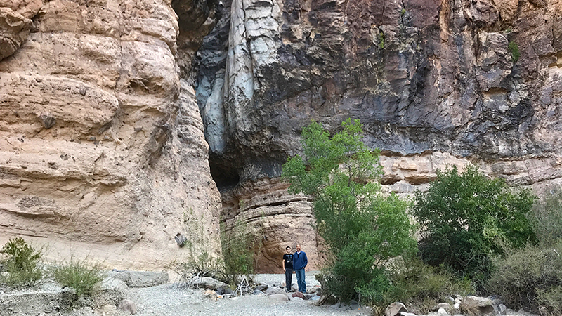
The trail mostly leads through a sand and gravel creek bed surrounded by a variety of desert plants and towering rich, red cliffs. The trail is easy, but walking through the sand in tennis shoes and/or hiking boots makes it feel like a bit more work.
Eventually we reached a split where you can turn continue straight or turn to the right. We weren’t sure which way to go, but luckily I took a photo of the trail map at the trailhead and we quickly figured out that the trail heads to the right. (On our way back out we had to help other hikers figure out the same thing!)
After following the trail a bit further, it curved around the side of the mountain and led us into a beautiful, shaded, narrow box canyon.
At the very back of the canyon, tucked almost out of sight to the left, is the pour-off. Here water has carved a deep channel into Burro Mesa as it plunged 100 feet to the base. This waterfall is usually dry and the smooth, polished pour-off attests to the power of water that floods the canyon during summer rains.
Know Before You Go
Lower Burro Mesa Pour-Off Trail is off the Ross Maxwell Scenic Drive:
- The Ross Maxwell Scenic Drive is a 30 mile adventure through the Chihuahuan Desert landscape of Big Bend National Park to the banks of the Rio Grande.
- Ross Maxwell Drive is an out and back road that begins near the park’s Maverick Entrance and has many vista points, scenic pullouts, educational displays, and short hikes.
- Don’t confuse the Lower Burro Mesa Pour-Off Trail with the Upper Burro Mesa Pour-off Trail. The upper trail is a moderate, 3.8 mile round trip hike to the top of the 100 foot Burro Mesa Pour-off. The trail includes some large rocks to climb down, where some rock scrambling may be necessary.
About Big Bend National Park:
- Big Bend National Park is located in Brewster County, southwest Texas. The name Big Bend refers to the great U-turn the Rio Grande makes in Southwest Texas.
- Park entrances are open 24 hours daily, all year. Entrance fee stations have variable seasons and hours.
- Admission fees are valid for seven days and are $30/vehicle, $25/motorcycle, $15/individual/bicyclist/pedestrian.
- There are five Visitor Centers in Big Bend National Park: Panther Junction, Chisos Basin, Castolon, Persimmon Gap, and Rio Grande Village.
- Download the Big Bend National Park maps.
- Big Bend National Park has more than 150 miles of hiking trails, including desert hikes in the Chihuahuan Desert, mountain hikes in the Chisos Mountains, and river hikes along the Rio Grande.
- Convenience stores are available and open year-round at Rio Grande Village, the Chisos Basin, and in the historic La Harmonia store at Castolon.
- Gas stations are located at Panther Junction and Rio Grande Village, and outside the park in Study Butte and Stillwell’s Ranch. Diesel is available at Panther Junction and outside the park in Study Butte.
- Pets are not allowed on trails, off roads, or on the river. Your pet can only go where your car can go and must be on a leash no longer than six feet in length or in a cage at all times. Pet etiquette and park regulations require that you always clean up after your pet and dispose of waste in trash receptacles.


