After Halema’uma’u Crater began erupting in March 2008 and volcanic fumes in the area created poor air quality, Hawai’i Volcanoes National Park closed Crater Rim Drive from Jaggar Museum to Chain Of Craters Road.
Today Halemaʻumaʻu continues to erupt. Crater Rim Drive remains closed to vehicles from Keanakākoʻi Crater to Jaggar Museum, but thanks to a sulfur dioxide monitoring network and air quality monitoring tools, the section of road from the Devastation Trail parking lot to Keanakāko’i Crater has been reopened to foot traffic only.
After visiting Jaggar Museum, the Kīlauea Overlook, Steaming Bluffs, the Sulfur Banks, and the Hilina Pali Overlook, we parked at the Devastation Trail parking area and began our hike 0.8 miles down the paved road to Keanakāko’i Crater.
You can definitely tell the road has been closed for a long time because ground cover and low-lying brush are slowly beginning to grow over the side of the road. And, because the road is lined with a thin forest of Koa and Ohi’a trees on both sides, there isn’t much to see and eventually, we all began to wonder, “Are we there yet?”. Finally the trees fell away and we were treated to a view of Keanakāko’i on the left and the barren, desolate Kīlauea Caldera on the right.
We decided to check out Keanakāko’i Crater first.
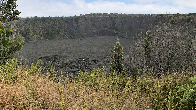
Keanakāko’i Crater, formed during the 1400s, is a 115 foot deep pit crater sitting on the boundary fault that encircles Kīlauea’s summit.
Keanakākoʻi means cave of the adzes. Ancient Hawaiians harvested the crater’s rare, hard basaltic rock to make adzes — tools used to carve objects like canoes, shelters, and homes. Similar to an ax, an adze was made with a sharp, hard basaltic head attached to a wooden handle.
In 1877, a lava flow buried the crater floor, ending access to the valuable stone and then during the Kīlauea fissure eruption in 1974, the floor of Keanakākoʻi was covered with another 20 feet of lava.
Kīlauea Fissure Overlook
Before beginning the 0.8 mile, slightly-uphill walk back to the parking lot, we walked across the street to another overlook.
From this roped overlook, you can see the fissures with still-smoking fumaroles from the 1974 Kīlauea eruption that lasted from July 19-23. This overlook also provides panoramic views of Kīlauea’s volcanic terrain, Halemaʻumaʻu Crater, and on clear days, the 13,677 foot summit of Mauna Loa and the 13,796 foot summit of Mauna Kea topped with astronomical observatories.
Know Before You Go
- Keanakāko’i Crater is located on Crater Rim Drive 0.8 miles past the road closure in Hawai’i Volcanoes National Park.
- Parking for the hike to Keanakāko’i Crater is at the Devastation Trail parking area 1.5 miles from the Thurston Lava Tube and 3.3 miles from the Kīlauea Visitor Center.
- The walk down Crater Rim Drive follows the two lane road with little to no shade. It is a hot and exposed walk, so come prepared with water, sunscreen, a hat, and layers to protect against wind and rain.
- While the accessible road is mostly flat, it is traveling slightly downhill toward the crater, which means you’ll be walking an uphill slope back to the parking area.
- Across the road from Keanakāko’i, another overlook provides views of fissures with smoking fumaroles from the 1974 eruption and expansive views across Kīlauea Caldera of Halemaʻumaʻu Crater and on clear days of Mauna Loa.
- The Keanakākoʻi area may still experience high levels of volcanic fumes with changing wind conditions. If this happens, the park will temporarily close the site to visitation.


