We have hiked around the American River Confluence in the Auburn State Recreation Area multiple times in the past, but it had been several years since our last visit. When we came back this past year to hike the Quarry Trail to Hawver Cave, I saw a gorgeous old bridge that I really wanted to check out. Unfortunately we had somewhere to be later that day and didn’t have time. Throughout the following week, I kept thinking about that bridge, so we planned another hike that would take us right across the old Mountain Quarries Railroad Bridge — the Canyon Creek Trail to the Black Hole of Calcutta Falls.
We got up early on a Saturday morning, were parked on the side of Old Foresthill Road by 7:30am, and set out for the waterfall. By being one of the first families on the trail for the day, we not only were able to hike and spend time at the small waterfall in peace and quiet, but we had plenty of time to hike down to the base of the bridge.
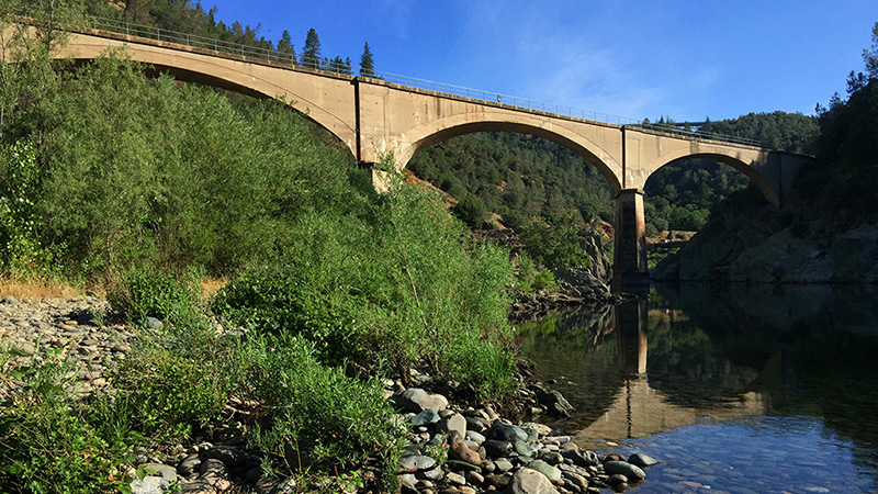
The Mountain Quarries Bridge has also been known as the Mountain Quarry Cement Bridge, the American River Quarry Bridge, the Pacific Portland Cement Company Railroad Bridge, the Auburn Concrete Arch Bridge, and No Hands Bridge. It spans the North Fork of the American River in the American River Canyon. With a long, very interesting history, the bridge today acts as a gateway to Auburn and the final American River crossing of the Western States 100 Mile Endurance Ride and Run and the Tevis Cup 100 Miles Day Trail Ride.

We hiked first, then spent time exploring the river and bridge before heading home — but at one point, I thought that might not happen.
When we visited the area for our previous hike on the Quarry Trail to Hawver Cave, I saw lots of people relaxing and picnicking at the water, so I knew there had to be some sort of trail. So while hiking to the Black Hole of Calcutta Falls, we looked for the way down to the base of the bridge. Up ahead of us, we saw a young couple turn left off the Canyon Creek Trail. We hurried forward to check out the trail and it was steep, rocky, and treacherous. Brian immediately said, “There is no way we’re going down that. Someone is going to get hurt.” I was so disappointed. I wanted to try it anyway — I’m always the one that pushes our adventuring limits. But Brian put his foot down and insisted safety is more important.
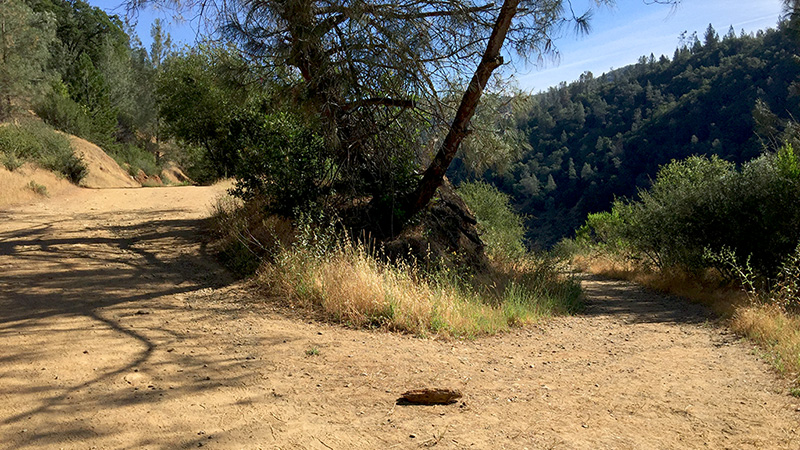
Thankfully, as we walked further down the Canyon Creek Trail, Carter discovered a second trail to the base of the old railroad bridge — one that was wider, flatter, and much safer. Hallelujah! We almost didn’t see the spur trail because it parallels the Canyon Creek Trail in the opposite direction and there is no signage, but Carter saved the day!
By the time we walked back toward the Mountain Quarries Railroad Bridge, the sun was blazing overhead and it was hot. Really hot. We could wait to get back to the bridge and down to the cool river water for a break and a snack.

Mountain Quarries Bridge
In 1910 the Mountain Quarries Company of San Francisco contracted the Duncanson-Harrelson Company to construct a railroad bridge to cross the American River just below the confluence of the North and Middle Forks, near their limestone quarry. Construction began in 1910, with a crew of 800 men working to build the $300,000 triple arch railroad bridge. In late 1911, three men died when the third arch collapsed. The bridge was completed and placed in service on March 23, 1912. At the time of it’s construction, the 482 foot long 150 foot tall bridge was the longest concrete skewed arch railroad bridge in the world.
Designed by John B. Leonard, one of California’s most renowned pioneers in the design, engineering, and promotion of the use of reinforced concrete for bridge construction, the Mountain Quarries Bridge proved that concrete was practical in building long arched bridges.
In 1964 when the Hell Hole Dam failed, the water came crashing down the Middle Form of the American River through the American River Canyon, destroying two modern, steel and concrete bridges that connected Placer County and El Dorado County. The historic Mountain Quarries Railroad Bridge survived and was used temporarily to restore vehicle traffic between the two counties. The concrete railroad bridge also survived complete submersion in the 1986 Valentines Day Flood.
In the early 1990s, because of damage to the bridge, the Bureau of Reclamation placed gates at each end to stop all traffic across it. Protestors jumped into action and a campaign called “Save No Hands Bridge” began, drawing in donations from around the world. Several studies helped create a plan to install a new foundation under the front of the damaged pier. Funding was difficult, but eventually $700,000 in federal disaster relief funds were secured for the necessary repairs. In 1999, the pier foundation and portions of the pier were repaired and the bridge was reopened to the public.
In 2004, Mountain Quarries Bridge was placed on the National Register of Historic Places by the Department of the Interior and in 2014, it was named a California State Historical Landmark. The bridge stands today as a proud monument to early day engineering and to the men who worked with somewhat primitive tools to create it.

Mountain Quarries Railroad
The Mountain Quarries Bridge is part of the Mountain Quarries Railroad and Mine (MQRR). The Mountain Quarries Railroad, owned by The Portland Cement Company, was built to connect the giant limestone quarry with the Southern Pacific mainline in Auburn, California. Due to its ownership, the railroad is often referred to as the Pacific Portland Cement Railroad or the Portland Cement Railroad.
The Mountain Quarries Company spent a reported one million dollars on constructing the mine, erecting up the crushing plant, and building the railroad line. The Mountain Quarries Railroad was seven miles long and ran from the quarry crushing plant in El Dorado County on the Middle Fork American River to Flint Station on the Southern Pacific main rail line in Auburn. There were 17 wooden trestles and one large concrete bridge — Mountain Quarries Bridge — on the rail line.
The Mountain Quarries Railroad operated until 1940/1941, when the company replaced the narrow-gauge trail with trucks. One year later, the railroad’s trestles and lines of tracks were removed and the materials, including the metal, were repurposed in the war effort. Over time the bridge became a popular pedestrian and horse crossing between Auburn and Cool.
Today, part of the old Mountain Quarries Railroad route is designated as the Western States Pioneer Express Recreation Trail.
No Hands Bridge
The Mountain Quarries Railroad Bridge is known locally as No Hands Bridge.
Today, No Hands Bridge is primarily used by horseback riders, runners, walkers, and hikers. While no one seems to have a definitive answer as to why the concrete bridge is called No Hands Bridge, there are a few main stories that keep popping up:
- Some say the Mountain Quarries Railroad Bridge is called No Hands Bridge because there were no hand railings on the bridge until 1986.
- Another story suggests that the name No Hands Bridge came from people riding horses or bikes across the bridge with no hands, yelling, “Look ma, no hands.”
- Yet another story about how the bridge became known as No Hands Bridge dates back to the early years of the Tevis Cup 100 Miles Day Trail Ride. It is said that while most horseback riders would walk their horses across the bridge, Ina Robinson, cheered on by the crowds, would let go of her reins and ride across the 150 foot tall, rail-less bridge using no hands.
Know Before You Go
- The Mountain Quarries Railroad Bridge, spanning the Middle Fork of the American River, is part of the Canyon Creek Trail to Calcutta Falls. The trailhead is located in the Auburn State Recreation Area near the American River Confluence.
- There is basically zero shade on the Canyon Creek Trail and none at the Mountain Quarries Railroad Bridge, so make sure you wear sunscreen and bring a hat.
- The rocky riverbank at the base of the bridge is the perfect place to have a picnic and splash around in the cool river water — just be sure you bring a lot of cold drinks, beach towels to spread out over the hot rocks, and maybe an umbrella.
- Skip the first, steep, rocky, narrow treacherous looking trail down to the water. Just a little farther up the trail there is a spur trail on the left side that is wide, flat, and not very steep. It’s not only a safer trail, but if you have an ice chest, beach towels, an umbrella, or anything else, this is the only way you’re going to get it down the the river’s edge.


