The McCloud River is one of the most spectacular and well-known waterways in Northern California. Flowing east of and parallel to the Sacramento River for 77 miles across Siskiyou County and Shasta County, the river is famous for its spectacular trio of waterfalls that pour over varying shapes of basaltic lava flows.
Often referred to as the Falls of the McCloud River or McCloud Falls, the three waterfalls are Lower McCloud Falls, Middle McCloud Falls, and Upper McCloud Falls.
Located six miles outside the town of McCloud, the McCloud River Falls Trail is a 3.8 mile round trip trail that links all three majestic waterfalls. It traverses the high desert forest landscape along the McCloud River shaded by pines, redwoods, fir trees, hemlocks, alders, ferns, dogwoods, and more.
We hiked the McCloud River Falls Trail from the Lower Falls Picnic Area, past the Middle Falls and Upper Falls to Lakin Dam, then turned around and hiked back. Our adventure traveled four miles and lasted a little more than four hours.
If you want to see the three waterfalls and aren’t into hiking or don’t have the ability to hike, there is an ADA accessible scenic overlook above each of the three waterfalls that you can drive to.
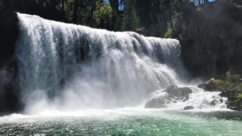
Lower McCloud Falls
We wanted to hike the entire McCloud River Trail and see all three waterfalls so we parked at the Lower McCloud Falls Picnic Area. Next to the parking lot is a paved observation platform with benches and picnic tables. We walked through the tables to the railing and were greeted with an amazing view of the McCloud River and the Lower Falls.
Lower McCloud Falls pours over a basaltic ledge and drops 12 feet into into a deep, sparkling, emerald green pool.
The area near the waterfall and the pools farther downstream are popular swimming holes for families looking to escape the heat. Large boulders and rock formations near the falls create perfect spots for cliff jumping if you’re brave, or you can climb down the rocks for a more gradual entrance.
We visited after an insane rainy season with numerous floods, and as a result the McCloud River was extremely full and the water was rushing so fast that very few people were actually getting in the water. Apparently, in years with less rain, the waterfalls are much calmer and the pools much safer to swim in.
After snapping some photos, we followed the concrete staircase to the left of the observation platform down to the rocky river bank to do some exploring and grab a few more photos. It was still early in the day, so we were one of just a few families in the area, so it was still quiet and really relaxing to just sit in the sun and listen to the rushing water for a while. With a wide stretch of flat, warm, sunny rocks, this is the perfect place for an afternoon picnic.


Soon we were ready to begin our hike. Above the Lower Falls, we followed the paved trail along the basalt river banks as the river began to narrow. After about a quarter mile, we reached Fowler’s Campground and followed the trail as it skirted the edge of the campground. This section of the McCloud River Falls Trail was pretty crowded with families, joggers, moms pushing strollers, and even bikers.
Once we made it past the campground, the paved trail turned to dirt and large trees rose high above creating a shady canopy. For the next mile, we followed the trail through the trees, catching glimpses of the rushing river through the brush.
We heard Middle McCloud Falls before we saw it, then when it came into view, we all let out an audible gasp. Middle McCloud Falls was absolutely incredible!
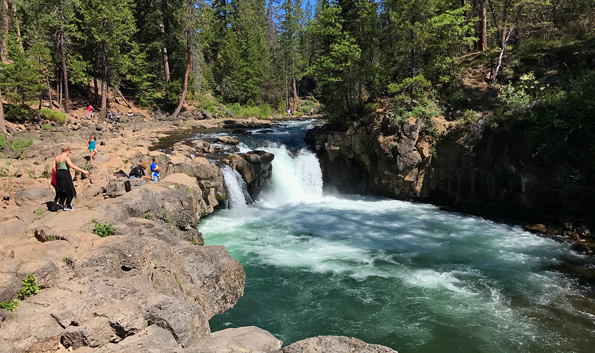
Middle McCloud Falls
The shoreline around the Middle McCloud Falls plunge pool is lined with huge boulders and rocks and without a second thought, we all began scrambling over the rocks to get a closer look of this stunning waterfall.
Middle McCloud Falls is 50 feet tall and close to 100 feet wide — and the sheer amount of water rushing over the basalt cliff was unbelievable and roar of the falls was so loud!
We climbed out to the boulders along the edge of the gorgeous pool below the falls and just sat in awe of it’s strength and beauty. The roar of the water was so great, we couldn’t even hear the hoards of people gathered around the trail’s edge snapping photos of the waterfall.
We have hiked to and seen a huge number of waterfalls of all shapes and sizes and I have never seen one of this magnitude. We all were actually completely caught off guard.
The photos we had seen of Middle McCloud Falls looked NOTHING like the waterfall we were looking at. In many of the photos I saw online, the water was trickling over the precipice at several places along the cliff’s edge. But during our visit, after the rain storms of early 2017, it was surging over the edge in a thick sheet of solid water.


Eventually, we made our way back to the trail so other hikers could enjoy the view from our rocks, and before heading up the steep section of trail to the Middle Falls Overlook, saw one brave soul cliff jump from above the waterfall! I know this is a popular spot for cliff jumpers and that this pool is a popular swimming hole throughout the summer, but with the water rushing as fast as it was, I just can’t imagine that cliff jumping was safe or smart.
After we saw the jumper pop his head out of the freezing water, we began our climb up three switchbacks and a wooden staircase to the overlook above the falls (which doesn’t do the falls justice at all). At the top of the stairs, we followed the trail to the right along the edge of the canyon rim and took in the amazing views of the McCloud River below. A paved trail leads away from the main trail to the Middle Falls Overlook parking lot and restrooms.
By this time it was early afternoon, the sun was blazing overhead, and it was hot — really hot — so we keptgoing to find Upper McCloud Falls.
Upper McCloud Falls
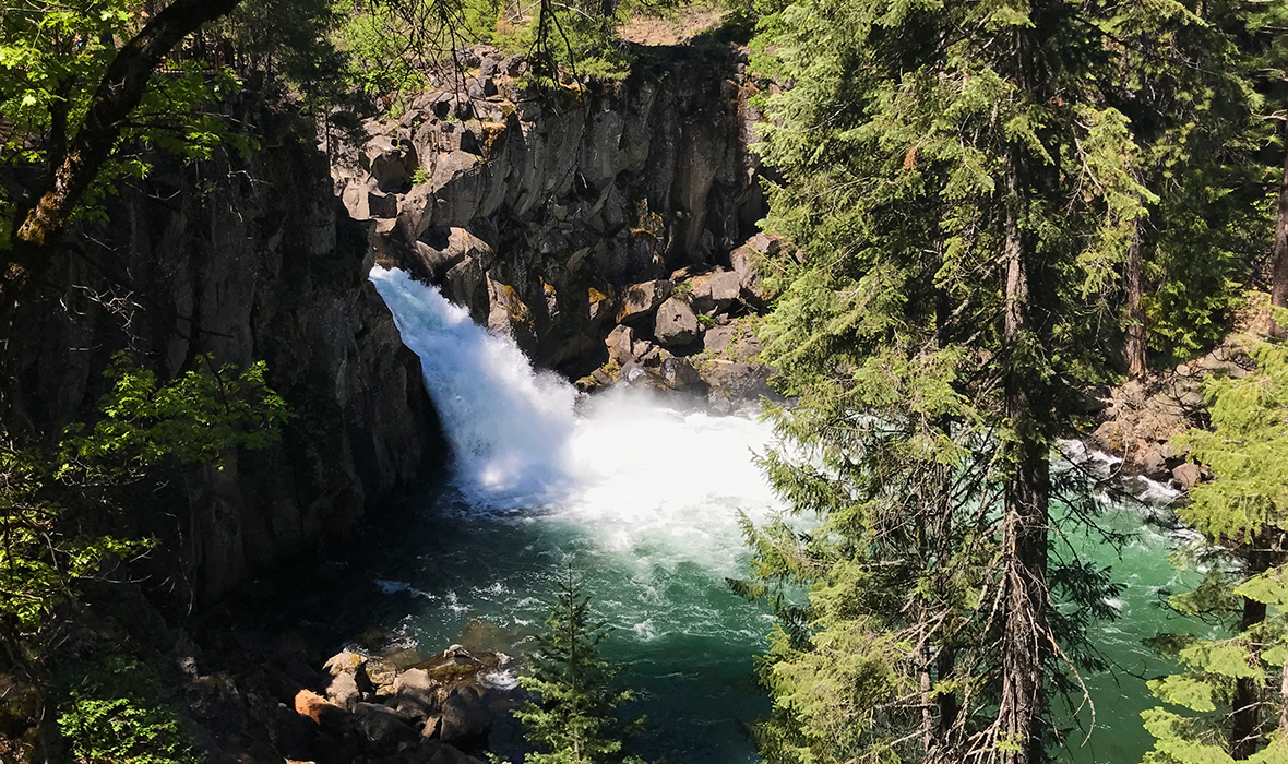
For a little over a quarter mile, we hiked through a shady stretch with of trees, thick brush, and wildflowers before reaching the first lookout point for Upper McCloud Falls. At this point, the trail is once again paved and provides ADA access to the Upper McCloud Falls Overlook with several different viewpoints above the falls to enjoy.
Upper McCloud Falls is a 25 foot waterfall that pours out of a narrow gorge cut through a 50 foot high basalt wall and drops into a beautiful plunge pool below.
While you can hike right up to Lower McCloud Falls and Middle McCloud Falls, jumping off the cliffs into the pools below and playing in the swimming holes, Upper McCloud Falls has no safe access at all. This waterfall is one that you appreciate from afar.


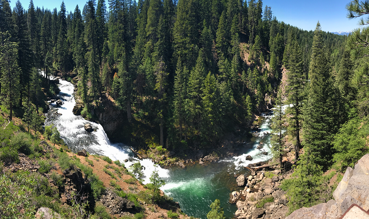
Just above the Upper Falls, also visible from the paved overlook area, is a very narrow section of the McCloud River that flows over volcanic rocks and through miniature pools, creating swirling eddys.
Most people turn around here to head back to the Lower Falls, or for those that prefer to drive a parking area. But we weren’t quite ready to be done with our hike and I wanted to go just a little further to see Lakin Dam.
As we followed the McCloud River upstream, we passed a few picnic tables and then found ourselves walking through a flat, lush, green meadow. The river changed as we walked as well, becoming much calmer and more peaceful.
Soon we once again heard the sound of rushing water, but it wasn’t from a waterfall. It was the sound of the water rushing over the top of the Lakin Dam.
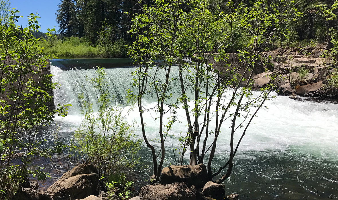
Lakin Dam is a concrete dam originally built in 1925 to provide water for an old lumber mill in McCloud.
After checking out Lakin Dam, resting under the shady trees, and having a snack, we began out hike back to the McCloud River Falls Trail trailhead at the Lower Falls Picnic Area. Because we had already taken a billion photos on the hike to the Upper Falls, we didn’t stop much at all on the mostly-downhill hike, and were back at the Lower Falls in about an hour.
When we arrived at Lower McCloud Falls we were in shock. There were people everywhere. It was wall-to-wall people like you might see at a southern California beach on a Saturday afternoon. All we could think was thank goodness we already explored this area and were on our way out!
Our McCloud Falls adventure lasted about four hours total and was worth every sweaty minute. Each of the three waterfalls were absolutely incredible in their own way and it’s obvious why this stretch of the McCloud River is one of the most popular attractions in the Mount Shasta region.
Know Before You Go
- McCloud Falls and the McCloud River Trail is located on Fowler Public Camp Road, McCloud, California 96057 in the Shasta Trinity National Forest near Mount Shasta, Siskiyou County.
- From I-5 North, take Exit 736 to merge onto CA-89 S/Volcanic Legacy Scenic Byway toward McCloud. Merge onto CA-89 S/Volcanic Legacy Scenic Byway and travel 15 miles. Turn right onto Fowler Public Camp Road and travel about 1.3 miles to the Lower Falls Picnic Area.
- The McCloud River Falls Trail is an out and back trail, totaling just under 4 miles round trip, that passes three waterfalls — Lower McCloud Falls, Middle McCloud Falls, and Upper McCloud Falls.
- The McCloud River Falls Trail is unique because you don’t have to hike the trail to see the waterfalls. Each waterfall can be accessed by a paved road that leads to scenic overlooks and observation areas.
- If you want to see the McCloud River waterfalls up close, you can hike the trail from the Lower Falls, past the middle Falls, to the Upper Falls.
- Download the McCloud Area Recreation Guide And Map
- Picnic areas are located at the Lower Falls and Upper Falls.
- Fowlers Campground is midway between the Lower Falls and Middle Falls.
- Best time of year to hike the McCloud River Falls Trail is April thru August.
- Get there early! By the afternoon, the McCloud River is crawling with hundreds of people, which means you also have to deal with all of the cars that brought the visitors to the area. The parking lot was such a complete disaster that it took us almost an hour to just get out of the parking lot. I am so grateful to those in front of us who were so frustrated they got out of their cars to direct traffic and stop new cars from coming down the road.