When we planned our spring break road trip from Capitol Reef National Park to Bryce Canyon National Park to Zion National Park, I was so excited to be able to visit so many other amazing Utah attractions — especially Grand Staircase-Escalante National Monument.
We drove Utah’s Scenic Byway 12 through the National Monument on our way from Capitol Reef to Bryce Canyon and made a day trip out of scenic drive. We stopped for jaw-dropping viewpoint after viewpoint and explored pit stops along the way like the Anasazi State Park Museum, Devil’s Garden Outstanding Natural Area, Hole-In-The-Rock Escalante Visitor Center, and Escalante Petrified Forest State Park.
Nearly double the total combined acreage of all of Utah’s national parks, the 1.9 million acre Grand Staircase–Escalante National Monument is the largest park in the Southwest and some of the most remote land in the country. The name refers to the 150 mile long geological strata that begins at the bottom of the Grand Canyon and rises, in steep stair steps, 3,500 feet in elevation to Bryce Canyon and Escalante River Canyon.
The Grand Staircase-Escalante National Monument, when designated by President Clinton, covered 1,880,461 acres of protected land in southern Utah. The monument’s size was reduced nearly 47% to 1,003,863 acres by President Trump in December 2017.
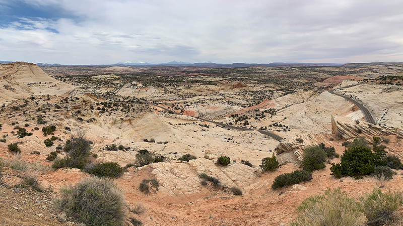
While our entire experience in the national monument offered incredible scenic views, the coolest part of our family adventure was driving along the famous Hogsback between Escalante and Boulder. This section of road traverses the narrow ridge with tight hairpin turns, steep drop offs into deep canyons lining each side of the road, and dramatic views of the surrounding slickrock canyon country.
Even though the wind was howling and it was freezing, we stopped to take in the views A LOT and took A LOT of photos! Someday I’d like to visit in warmer weather and explore Calf Creek Falls and the slot canyons of Bull Valley Gorge, Willis Creek, and Lick Wash.
Three Sections Of The National Monument
Grand Staircase-Escalante National Monument is divided into three distinct sections:
- The Grand Staircase
- The Kaiparowits Plateau
- The Canyons of the Escalante (Escalante River)
Grand Staircase
The Grand Staircase is a series of plateaus descending 3,500 feet from Bryce Canyon south toward the Grand Canyon. The staircase was formed when the Colorado plateau lifted and layers of sedimentary rock below fanned out below. The exposed layers reveal 260 million years of geological history, marked by steep, colorful vertical drops at the Pink Cliffs, Grey Cliffs, White Cliffs, Vermillion Cliffs and Chocolate Cliffs.
Kaiparowits Plateau
At nine thousand feet elevation, the 1,600 square mile Kaiparowits Plateau is the highest, most remote part of the monument. Its sedimentary rock formations contain an unbroken record of fossils spanning 30 million years.
Canyons Of The Escalante
Canyons Of The Escalante is a dramatic, desolate landscape. It showcases the rock left after the Escalante River carved through the earth, creating towering cliff walls, spectacular rock formations, narrow canyons, and stunning grottos. The Escalante River Canyons presented a barrier to exploration until the Powell expeditions in the mid-1800s. In 1941 the National Park Service began studying the Escalante River area — the last area of land in America to be discovered and mapped.
National Monument Visitor Centers
Visitor centers with area information, exhibits, gifts, and topographic maps of the Grand Staircase–Escalante National Monument are located in the national monument’s bordering towns:
- Escalante Interagency Visitor Center is the main visitor center for the Escalante Canyons area. Here you can find exhibits on regional scientific discoveries in botany, ecology and biology. It is located at 755 W. Main Street, Escalante, Utah 84726.
- The Grand Staircase Visitor Center in Kanab features archaeological and geologic exhibits. It is located at 745 East Highway 89, Kanab Utah 84741.
- The Cannonville Visitor Center, on the north side of the monument along Scenic Byway 12, explains the early Paiute and Pioneer life. Located at 10 Center Street, Cannonville, Utah 84718, this location is closed in the winter.
- The Big Water Visitor Center, on US Highway 89, features geology and paleontology exhibits, a mural covering one entire side of the center that shows dinosaurs and their habitats, and a big picnic area. It is located at 669 South Highway 89A, Kanab, Utah 84741.
Know Before You Go
The remote, undeveloped Grand Staircase-Escalante National Monument is administered by the Bureau of Land Management (BLM) as part of the National Conservation Lands system.
- Grand Staircase-Escalante was declared a national monument in 1996, under executive order by President Bill Clinton.
- The national monument is mostly undeveloped territory. The Bureau of Land Management (BLM) recommends only camping in established campgrounds. If you do camp, understand that there are no facilities, which means you are responsible for properly disposing of waste and litter.
- Grand Staircase-Escalante National Monument is home to 200 species of birds (including the Bald Eagle and Peregrine Falcon), nearly 60 species of mammals, dozens of reptiles and amphibians, and several types of fish.
- Visitors should be aware of environmental threats like extreme temperatures, sudden storms, flash floods, deep water in slot canyons, quicksand, slick rock, and steep cliffs.
- Fun family-friendly stops in the monument include: Devil’s Garden Natural Area off Hole-in-the-Rock Road, Grosvenor Arch off Cottonwood Canyon Road, Anasazi Indian State Park, Escalante State Park, Johnson Canyon, Bull Valley Gorge, and Kodachrome Basin State Park.
- You can drive Scenic Byway 12 from Capitol Reef National Park to Bryce Canyon National Park through Grand Staircase–Escalante National Monument and across its famous “hogback ridge.”


