Last year, while camping at Half Moon Bay, we spent a day exploring the surrounding California coastline, stopping at Point Montara Lighthouse, Pescadero State Beach, and Pigeon Point Light Station. We also drove into Pacifica, California, but because it was starting to rain, we decided to head back to camp.
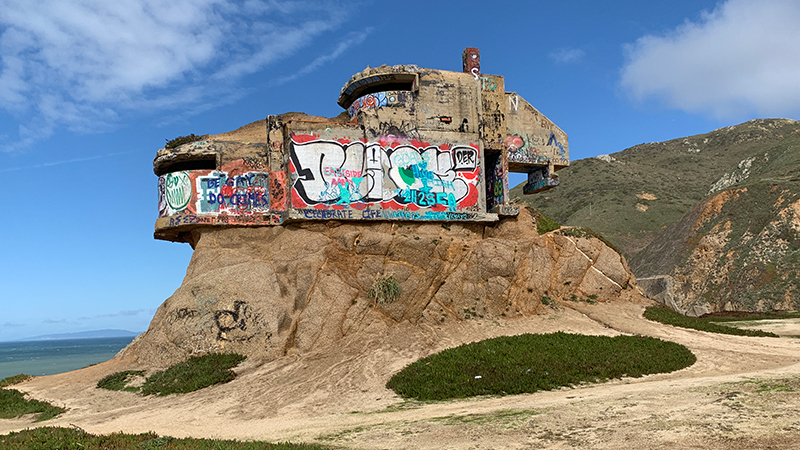
Ever since that day, I have wanted to go back to Pacifica — and not just because it is the location of the most scenic Taco Bell in the world. We drove by this eerie looking concrete building teetering on a rock on the edge of a cliff and I wanted to get a closer look but it was getting dark and the rain was starting.
Luckily, this past weekend while in San Francisco, we took a side trip back to Pacifica and stopped at the old, abandoned, graffiti-covered building — it turned out to be an old military bunker and the area where it sits is called Devil’s Slide.
Devil’s Slide
Devil’s Slide is a steep, rocky coastal promontory on the San Mateo County coast between the quaint coastal towns of Pacifica and Montara, California. A stretch of California State Route 1, also known as Highway 1 and the Pacific Coast Highway, is also called Devil’s Slide because of it’s frequent closures and landslides during winter storms.
The road was built in 1935-1936 to circumvent the rather dangerous Pedro Mountain Road. A major landslide in 1940 destroyed much of the road, another in 1995 closed the road for almost two years, and in 2006, the road began to crack again signaling a future collapse and it was closed for five months.
In 2013, Caltrans shut down the Devil’s Slide portion of Highway 1, rerouting it through the Tom Lantos Tunnels that cut right through the mountainside. In 2014, the old stretch of road was reopened to the public as the 1.3 mile, paved Devil’s Slide Trail, which is open to bicyclists and pedestrians. Eventually, it will become part of the California Coastal Trail.
The Devil’s Slide Bunker
Traveling south out of San Francisco on Highway 1, after driving through the Tom Lantos Tunnels, you’ll see the gorgeous curving coastline, the blue Pacific ocean, and an old concrete building teetering atop a rock — and it looks like it’s about to slide right into the sea below! Immediately south of the tunnels is a small parking lot. It’s officially the southern parking lot for the Devil’s Slide Trail but if you walk along a dirt trail in the opposite direction, you can reach an abandoned concrete bunker.
Sitting high above Gray Whale Cove State Beach, on a coastal bluff referred to as both Devil’s Peak and Bunker Point, is the Devil’s Slide Bunker, which was built during World War II as a triangulation and observing station.
Devil’s Slide Bunker was part of Little Devils Slide Military Reservation — one of five fire control stations built by the Army at Devils Slide as part of the harbor defense of San Francisco.
There were six military structures at Devil’s Slide:
- Three concrete and steel observation pill-boxes
- Two concrete and earth bunkers
- A reinforced steel observation tower
In the bunker, soldiers used binoculars to watch for attacking Japanese ships. If spotted, they would radio the enemy’s coordinates to gun batteries in the Marin Headlands and at Fort Funston.
Eventually, radar technology advanced, the station became obsolete, and it was abandoned in 1949. The land was purchased by a private owner in 1983 and all buildings except for the bunker were removed. At one point, much of the bluff was carved away for construction, but plans to develop the property were abandoned and now the bunker sits 15 feet off the ground, teetering on a rock, covered in graffiti.
While technically the old concrete bunker sits on private land with restricted public access, it is easily accessible so lots of people visit it — including us!
We parked in the nearby parking lot and walked over to the bunker to explore the bluff and check out the abandoned building up close. While we were there another couple were doing some exploring too and one of them climbed up into the bunker through the narrow opening on the coastal side! He reported back that the inside was empty but also covered in graffiti.
Know Before You Go
- The Devil’s Slide World War II era military bunker and observation post is located just off the Pacific Coast Highway (Highway 1) in Pacifica, California 94044 in San Mateo County.
- Devil’s Slide Bunker sits on private property and is technically not open to the public, but a nearby parking area for the Devil’s Slide Trail, easy access along a short dirt trail, and no fencing mean that people stop to check it out and walk around every day.
- The parking area is officially the southern parking lot for the paved, 1.0 mile Devil’s Slide Trail and is located immediately south of the Tom Lantos Tunnels.
- The dirt trail to the bunker is only about 500 feet from the parking lot. Be careful when exploring the bluff. The edges of the steep cliffs are unstable.
- Thick fog can make it hard to see the bunker from the road but on clear days, you can’t miss it.
- Gray Whale Cove State Beach is 0.3 miles south of the Devil’s Slide Bunker and Montara State Beach is 1.1 miles south. Point San Pedro Beach sits 1.6 miles to the north and Shelter Cover Beach is 1.8 miles north.


