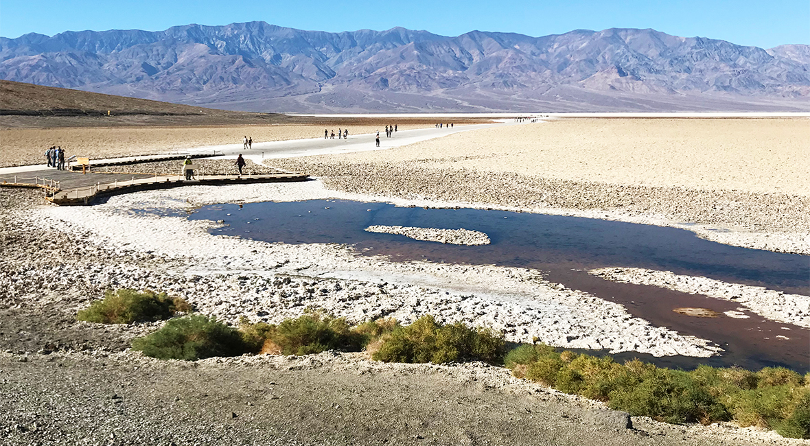
Death Valley is the hottest, driest, lowest place in North America, and at an elevation of 282 feet below sea level, Badwater Basin covers more than 200 square miles of the Death Valley floor. It is one of the largest protected salt pans in the country and one of the most popular attractions in the national park. We had seen large salt patches on the ground while exploring the floor of Death Valley and walking the Salt Creek Trail, but that was nothing compared to the Badwater Salt Flats!
After hiking through Golden Canyon and visiting Devil’s Golf Course, we visited the massive, white salt flat before heading to Natural Bridge Canyon and Artists Palette.
Badwater Salt Flat Hike
The hike into the Badwater Salt Flats of Badwater Basin isn’t really a hike at all, but an easy, flat, out-and-back walk, which makes it one of the most popular and easily accessible sites within Death Valley National Park.
Stairs and an ADA accessible ramp lead from the parking lot to a wooden platform overlooking Badwater Pool, a small sodium chloride pond and interpretive displays. There is also an elevation sign, marking the lowest point in the Western Hemisphere. It’s a fantastic photo spot with the bright, white salt flats in the background.
After snapping a couple family photos, we followed the wooden boardwalk onto a wide, flat path of salt that has been worn smooth. The main salt path stretches a mile out into the salt flats, and while walking a mile doesn’t seem like a big deal, it is on the salt flats! It was hot. Insanely hot. Much hotter than it was in Devil’s Golf Course or even in the Badwater parking area. I can’t even imagine it in the summer when the floor of the salt flats reach almost 200 degrees!
It was pretty incredible to stand at the bottom of Badwater Basin, in the salt flat, surrounded by the Panamint and Amargosa Mountains. We were hot and sweaty and tired, but we had a mission before turning back: Taste salt from the Badwater Salt Flats. We all tasted the salt, Natalie even put it on a cracker, and it tasted just like good old fashioned table salt!
Then with Telescope Peak towering above us across the valley, we explored the salt flat a bit more and checked out the halite salt formations before walking back to the car for some ice cold water.
Badwater Pool
Water is rare and precious in Death Valley, and according to the informational displays, when a surveyor mapping the area found the water, he couldn’t get his mule to drink from it because of its salinity. He wrote on his map that the spring had “bad water” and the name stuck.
Pickleweed, aquatic insects, and larvae live in the Badwater Pool, proving it is not poisonous just salty. It is also home to one of Death Valley’s rarest animals — the Badwater Snail. These tiny mollusks exist only in a few springs at the edge of the Death Valley salt flats.
Ancient water fills Badwater Pool year-round. Much of the water began as Ice Age snow and rain hundreds of miles away in the central Nevada mountains. The runoff seeped into limestone bedrock and began a long underground flow through a regional aquifer before emerging at Badwater along the faultline at the mountain’s base. Salts dissolve from old deposits and flow to the surface, making the spring water “bad.”

Badwater Salt Flat
The vast salt flats of Badwater Basin change constantly. Salt crystals expand, pushing the crust of salt into rough, chaotic forms. Newly formed crystals ooze between mudcracks, creating strange patterns on the surface of the salt flat. Passing rainstorms wash off the windblown dust and generate a fresh layer of blinding white salt. Floods create temporary lakes that dissolve salts back into solution, starting the process all over again.
Sodium Cloride, better known as table salt, make up the majority of the salts on Badwater Basin, along with other evaporative minerals like calcite, gypsum, and borax.
The source of Badwater’s salts is Death Valley’s drainage system of 9,000 square miles — an area larger than New Hampshire. Rain falling on distant peaks creates floods that rush down the mountains. Along the way, minerals dissolve from rocks and join the flood. In Badwater Basin at the lowest elevation, the floods come to rest, forming temporary lakes. But the lakes don’t last long, and as the water evaporates, minerals concentrate until only the salts remain. After thousands of years, enough salts have washed in to produce layer upon layer of salt crust.
Know Before You Go
- The Badwater Salt Flat in Badwater Basin is located directly off Badwater Road about 30 minutes south of Furnace Creek in California’s Death Valley National Park.
- The parking area is large and paved, and there are vault toilets and informational displays.
- Badwater Basin is 282 feet below sea level, while visiting, be sure to turn around and look up the cliffs behind the parking lot to see a sign marking sea level. Stop and take a quick photo with the elevation sign!
- Once you walk out onto the salt flat, it gets hot, really hot, especially with the white salt floor reflecting the sunlight and heat back up at you. It is not recommended to walk out into the salt flat in high heat.
- The Badwater Salt Flat hike is a flat, easy one mile out and back walk that totals two miles. You can walk across the entire salt flat — it’s a five mile walk each way!
- Be sure to bring water with you!


