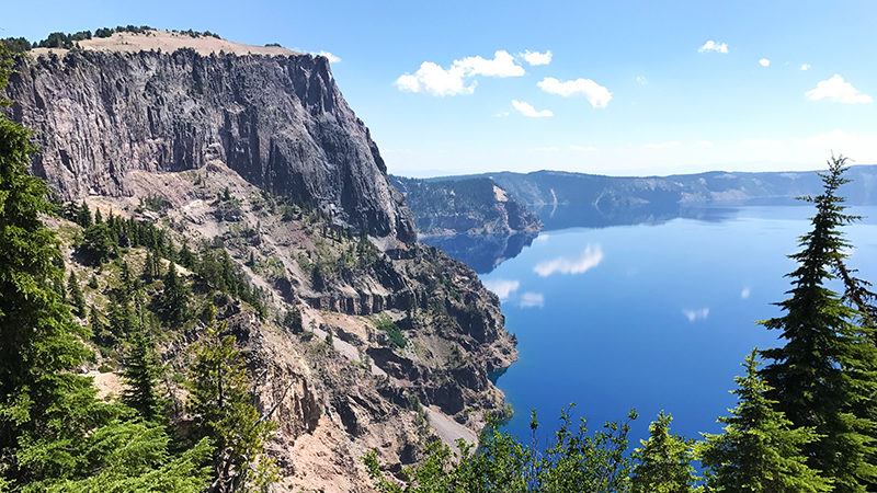
After checking out the views of Crater Lake at Discovery Point, Watchman Overlook, and Merriam Point, and even playing a bit in the snow in late July, we pulled into the Llao Rock Overlook parking area ready for another view of the stunning, clear blue lake. We got our first look at Llao Rock from the Merriam Point Overlook wanted to get a closer look at the towering lava formation…
With its face standing 1200 feet tall, Llao Rock is one of the highest points on the rim of Crater Lake’s caldera, reaching an elevation of 8,046 feet.
Llao Rock was formed during a volcanic eruption, when a 1200 foot thick flow of molten dacite lava poured out of a vent on the upper slopes of Mount Mazama, filled an explosion crater, and hardened after moving only a mile or two. The flow preceded the great eruption that caused the collapse of Mount Mazama by 150-200 years. During that eruption, a large portion of formation fell into the caldera.
Today, Llao Rock towers above Crater Lake, capped by a thick layer of light volcanic ash from the Mount Mazama eruption. It was named by William Gladstone Steel after the Native American god Llao who ruled the “below world” and lived beneath Mt. Mazama.
From the viewpoint, if you look across the lake, you can see Pumice Point and the stem of the Wineglass formation in the caldera wall.


Llao Rock Research Natural Area
The 435 acre Llao Rock Research Natural Area (RNA), located along the northwest caldera rim, is closed to public entry whenever the area is covered by less than one continuous foot of snow. It was designated in 1994 to protect rare plant species and preserve Whitebark pine communities, subalpine pumice and ash fields, and an alpine community mosaic that has been damaged by hiking activity.
Know Before You Go
- Crater Lake National Park, Oregon’s only national park, does not have a physical street address, so it can be hard to locate us using GPS. We made the historic Crater Lake Lodge our first stop, which is located at 565 Rim Drive, Klamath Falls, Oregon 97604.
- At 1,943 feet deep, Crater Lake is the deepest lake in the United States and the principal feature of Crater Lake National Park.
- The 33 mile Rim Drive that travels around Crater Lake’s caldera features spectacular views of the lake and interpretive signage at all of the main vista points.
- Good for seven days, admissions fees are $30.00/vehicle, $25.00/motorcycle in the summer and $15.00/motorcycle in the winter, and $15.00/pedestrian or bicycle.
- The national park is open year-round, 24 hours a day but many of the park’s roads, trails, and facilities are closed seasonally.
- During periods of rain and snow, Crater Lake is often hidden by clouds — it is completely invisible about 50% of the time in the winter!
- Summers at Crater Lake are short but typically sunny. July, August, and September are your best bets for warm, dry weather. However, it can snow any day of the year.
- The park’s North Entrance is closed for about seven months each year. It closes at the first snowfall or on November 1, whichever comes first and reopens in early to mid-summer. The park’s South Entrance and West Entrance are open year-round. We visited the park in late July and the roads had only been open for a week!
- Crater Lake National Park has two visitor centers. The Steel Visitor Center at Park Headquarters is open every day except December 25 — 9:00 am to 5:00 pm from mid-April to early November and 10:00 am to 4:00 pm the rest of the year. The Rim Visitor Center at Rim Village is open daily from late May to late September from 9:30 am to 5:00 pm.
- Dogs on-leash are permitted within the park but only within developed areas and within Mazama Village and Lost Creek Campground. Dogs are not permitted on any trails or in undeveloped areas.