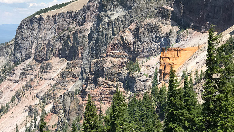
From roadside waterfalls and mountainside tumbling cascades to spectacular scenic viewpoints and geologic formations, Crater Lake National Park offers visitors so much more than pretty views of Crater Lake. Just 1.1 miles west of Cloudcap Overlook and 2.4 miles east of Phantom Ship Overlook is a turnoff on East Rim Drive that that leads to an eye-catching formation named Pumice Castle. It’s a viewpoint that is missed by many park visitors because it is unmarked and there are no signs.
Pumice Castle, also called Castle Rock, is a colorful, bright orange and pink volcanic formation shaped like a medieval castle.
Sitting 1,300 feet above the surface of the lake, the formation is part of a bed of fragmental pumice outcropping on the east caldera wall of Crater Lake that reaches up to 190 feet thick.
Pumice Castle Viewpoint is just that: a viewpoint where you can see the castle, surrounding Redcloud Cliff and the lake. There is no hiking access to Pumice Castle.
The Formation Of Pumice Castle
At this scenic overlook and another roadside pullout, Crater Lake National Park signs share a little bit about how Pumice Castle was formed.
Mount Mazama, the collapsed volcano that holds Crater Lake, grew through repeated eruptions of different kinds over half a million years as seen in layers in the caldera walls. Lava oozed from the top or side vents, erupted as red-hot avalanches that poured down the slopes, or exploded into the air and fell as cinders or globs.
Pumice Castle, shaped like the battlements of a castle, formed 70,000 years ago when pumice and other rocks and lavas welded together at high temperatures. These air-fall deposits were buried and compacted by the Redcloud Cliff flow, then exposed when Mount Mazama collapsed. A hardened base of andesite lava has kept Pumice Castle intact as wind, snow, and rain have eroded the softer materials into turret shapes that resemble a medieval castle.
Know Before You Go
- Crater Lake National Park, Oregon’s only national park, does not have a physical street address, so it can be hard to locate us using GPS. We made the historic Crater Lake Lodge our first stop, which is located at 565 Rim Drive, Klamath Falls, Oregon 97604.
- At 1,943 feet deep, Crater Lake is the deepest lake in the United States and the principal feature of Crater Lake National Park.
- The 33 mile Rim Drive that travels around Crater Lake’s caldera features spectacular views of the lake and interpretive signage at all of the main vista points.
- Good for seven days, admissions fees are $30.00/vehicle, $25.00/motorcycle in the summer and $15.00/motorcycle in the winter, and $15.00/pedestrian or bicycle.
- The national park is open year-round, 24 hours a day but many of the park’s roads, trails, and facilities are closed seasonally.
- During periods of rain and snow, Crater Lake is often hidden by clouds — it is completely invisible about 50% of the time in the winter!
- Summers at Crater Lake are short but typically sunny. July, August, and September are your best bets for warm, dry weather. However, it can snow any day of the year.
- The park’s North Entrance is closed for about seven months each year. It closes at the first snowfall or on November 1, whichever comes first and reopens in early to mid-summer. The park’s South Entrance and West Entrance are open year-round. We visited the park in late July and the roads had only been open for a week!
- Crater Lake National Park has two visitor centers. The Steel Visitor Center at Park Headquarters is open every day except December 25 — 9:00 am to 5:00 pm from mid-April to early November and 10:00 am to 4:00 pm the rest of the year. The Rim Visitor Center at Rim Village is open daily from late May to late September from 9:30 am to 5:00 pm.
- Dogs on-leash are permitted only in developed areas of the park and in Mazama Village and Lost Creek Campground. Dogs are not permitted on any trails or in undeveloped areas.


