Multnomah Falls was our last stop on our Columbia River Gorge day trip. It was the most anticipated waterfall of the day, so we saved it for last — a great way to finish off an amazing day of hiking and exploring. Except, that while the the 620 foot, two-tier waterfall is absolutely incredible, the experience of actually visiting the falls was our least favorite part of the day.
Almost immediately after leaving the Wahkeena Trailhead to go to Multnomah Falls, we came to a dead stop and regretted not hiking the extra half mile to the falls from the Wahkeena Trailhead. Yes, there was a reason we saw so many people doing that. Traffic was backed up all the way down the road in both directions from the stunning, famous Oregon waterfall — and it wasn’t even a weekend day!
This natural wonder attracts approximately 2.5 million visitors per year, ranking Multnomah Falls as Oregon’s number one visited natural attraction.
We had already visited Bridal Veil Falls, Shepperd’s Dell Falls, Latourell Falls, Vista House, Wahkeena Falls, and Fairy Falls, and our legs were tired. Plus, we didn’t have a ton of time to spare because we needed to get back to Portland and shower up for dinner and Dead and Company at the Moda Center later that night. I really didn’t want to go back to the Wahkeena Trailhead and hike in, I didn’t want to park far away and ride a shuttle in, and we definitely didn’t have time to ride a bus to Multnomah Falls from Portland. Thankfully Brian looped the parking lot a few times for me and we ended up finding a parking space right across the street. Amen!
The minute we crossed the Historic Columbia River Highway, walking toward the Multnomah Falls Lodge, we were overwhelmed with hoards of people. The crowds were absolutely insane. Unlike the other waterfalls we had visited, where the experience was peaceful and quiet, Multnomah Falls was busy, loud, and a bit stressful.
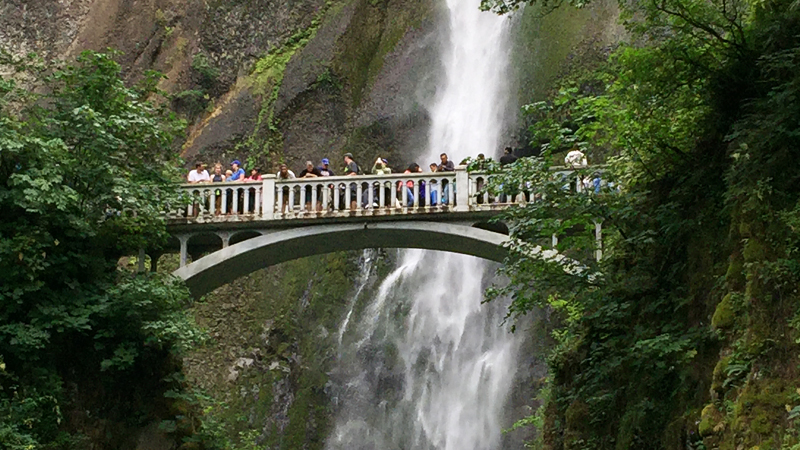
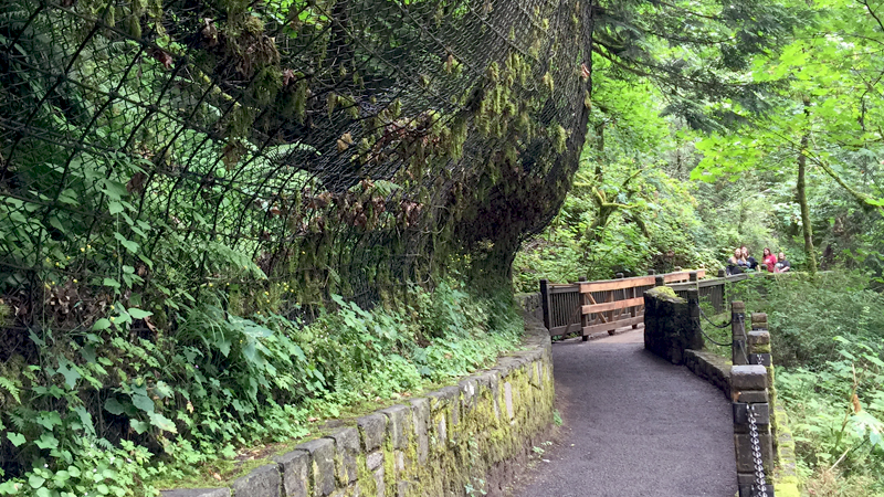
It was difficult to get a great view of the entire falls from the overlook and viewing platform because everyone was trying to squeeze into the same space to take photos and selfies, and some adults even shoved my children to get a good spot. I finally gave up and had the kids stand on the corner of a bench to snap a quick photo before heading up the trail to Benson Bridge, the footbridge the base of the falls’ upper tier. The walk up to the bridge was fine, but there were so many people on the bridge that it was difficult to even cross! And don’t even get me started on the anxiety and claustrophobia I felt inside the overly-crowded gift shop — and I don’t even suffer from anxiety or claustrophobia!
While our experience wasn’t ideal, we’ll definitely be back — on a weekday, mid-week, first thing in the morning. I really want to experience the falls in a peaceful setting, and we all want to do the full hike to the top of Multnomah Falls.
Multnomah Falls
At 620 feet, Multnomah Falls is the tallest waterfall in Oregon and the second tallest year-round waterfall in the United States. It is fed year-round by underground springs from Larch Mountain and augmented by snow melt and rainwater. Due to the easily eroded basalt landscape at the base of the upper falls, the waterfall plunges to the ground in two tiers, with Upper Multnomah Falls dropping 542 feet and Lower Multnomah Falls dropping 69 feet. There is a gradual nine foot drop in elevation between the two, giving the falls its total height of 620 feet.
Multnomah Creek initally fell over a flat cliff face. Its present bowl shaped amphitheater was created during 12,000 winters as spray from the falls froze onto the cliffs. The ice expanded in cracks and broke off pieces of rock which were carried away by the creek. Recent rock chips can bee seen at the base of the cliff.
The small, deep pool between the two tiers of Multnomah Falls used was a swimming hole until Labor Day 1995, when a 400 ton boulder, loosened by erosion, separated from the basaltic cliff side and fell more than 200 feet into the upper cascade pool above Benson Bridge. The boulder drop caused a 70 foot wall of water and gravel to splash over the bridge. A sign near the waterfall says the rock was the size of a school bus. At the time, a wedding party was standing on the bridge posing for pictures, and twenty received minor injuries.
A 30 minute drive from Portland, Multnomah Falls is a famous icon of the Pacific Northwest that sits directly off the Historic Columbia River Highway. Along with Benson Bridge which crosses the base of the upper falls, it is one of the most photographed locations in Oregon. It is also one of the best places in the Columbia River Gorge National Scenic Area to study geology exposed by floods with five flows of Yakima basalt visible in the falls’ cliff face. The upper falls can be seen from the Highway, but to see the lower falls, you need to walk out to the stone viewing deck.

Larch Mountain Trail
The 1.2 mile out and back Larch Mountain Trail (Multnomah Falls Trail) to the top of Multnomah Falls, is a steep trail with many switchbacks, climbing approximately more than 700 feet to the top of the falls. The 2.4 mile round trip hike leaves from the Multnomah Falls Lodge Visitor Center and after .2 miles, crosses the historic Benson Bridge. From the bridge the trail continues 1 mile to the top of the basalt cliff. Before heading back down to the Lodge, follow a short spur trail to a small viewing area at the very top of the falls. If you want a longer hike, you can continue on Larch Mountain Trail for six miles to the top of Larch Mountain.
Benson Bridge
One day while out at the site with Simon Benson, Samuel Lancaster remarked that it would “be nice if there were a footbridge across the lower waterfall, with a path up to and across it so that visitors could … look up at that magnificent waterfall above, then without moving look down on the lower one into the pool below.” Benson inquired about the potential cost, Lancaster calculated the figures on the back of an envelope, and Benson wrote a check for the amount, directing Lancaster to build it.
Benson Bridge, named for Simon Benson was built in 1914. It is a 45 foot long reinforced-concrete deck arch footbridge that sits just under a quarter mile up the Multnomah Falls Trail. The bridge allows visitors to cross 105 feet above the Lower Multnomah Falls cascade. From the bridge, visitors can continue on the paved trail to a viewing platform at the top of the falls with spectacular vistas of the waterfall, Multnomah Falls Lodge, the lower observation deck, and the Columbia River Gorge.
Benson, a lumber baron and philanthropist, later purchased nearly 1,000 acres along the Columbia River, including the 140 acres around Multnomah Falls, and gifted it to the city of Portland for a park. In addition to funding construction for the Benson Bridge at Multnomah Falls, Benson also funded construction of the Wahkeena Falls Bridge at Wahkeena Falls in 1915.

Multnomah Falls Lodge
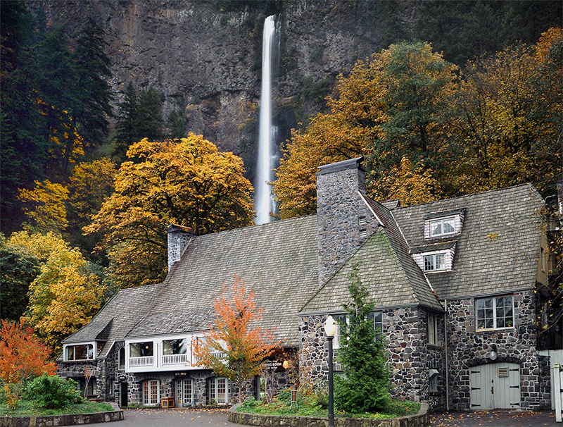
The Washington Railroad and Navigation Company donated the property for the lodge to the City of Portland, with the agreement that the city would fund the construction of the Lodge. In 1925, the city hired A.E. Doyle, a noted Portland Architect well known for his designs of the US Bank, Meier and Frank, Lippman Wolfe, and Reed College buildings, to design the Multnomah Falls Lodge. The Shattuck Company constructed the Cascadian-style stone and timber building at a cost of $40,000 and it was completed the same year.
The Historic Multnomah Falls Lodge provided meals and lodging for travelers touring the Columbia River Gorge. The first concessionaire of the lodge was Rolla Simmons, who operated the Simmons Hillvilla restaurant in Portland. Simmons operated the food services at the lodge until November of 1942, at which time the lodge was closed for the duration of World War II, until it reopened in 1946. The ownership of the lodge transferred to the US Forest Service in 1939, and is currently operated by the Multnomah Falls Co.
In 1981, Multnomah Falls Lodge and the Multnomah Falls Footpath were listed on the National Register of Historic Places. Today the lodge houses the Multnomah Falls Lodge Restaurant, Gift Shop, Snack Bar, Espresso Bar, Restrooms, and Interpretive Center. The Visitor Information Area is jointly staffed by Friends of Multnomah Falls and the U.S. Forest Service. Outside near the footpath, coffee and snacks are available under pop-up tent and a “quick-serve” food area is tucked around the side of the building.
The Multnomah Falls observation area between the lodge and Benson Bridge, along with adjoining stone walks, benches, and interpretive displays, has been remodeled continually since the 1920s. Beginning in the late 1980s, Multnomah Falls Scenic Area came under the jurisdiction of the newly organized Columbia River Gorge National Scenic Area, with planning strategies for its future coordinated with similar U.S. Forest Service activities at other sites in the gorge.

Multnomah Creek Bridge
When driving on the Historic Columbia River Highway, you will cross Multnomah Creek over the Multnomah Creek Bridge, a significant component of the Historic Columbia River Highway. It is a short-span barrel arch with a reinforced concrete deck measuring 67 feet in length, and solid spandrel walls measuring 40 feet in length. The bridge was designed by K.P. Billner under the supervision of C.H. Purcell, State Bridge Engineer, and S.C. Lancaster, Assistant State Highway Engineer. It was constructed in 1914 by the Pacific Bridge Company of Portland.
Know Before You Go
- Multnomah Falls Lodge and Multnomah Falls is located at 53000 E Historic Columbia River Highway, Bridal Veil, Oregon 97010 in Multnomah County.
- Traveling west from Multnomah Falls, it is 0.5 miles to Wahkeena Falls and Fairy Falls, 3.5 miles to Bridal Veil Falls, 5 miles to Shepperd’s Dell Falls, 6 miles to Latourell Falls, 8.5 miles to Vista House at Crown Point, and 9.5 miles to the Portland Women’s Forum Scenic Overlook. Traveling east, it is 2 miles to Oneonta Falls, 3 miles to Horsetail Falls, and 7 miles to Elowah Falls.
- Download a Columbia River Highway Waterfall Map, documenting the waterfalls between Corbett and Dodson.
- This is by far the most crowded waterfall in Oregon’s Columbia River Gorge, with parking lots filling fast and shuttles busing in visitors from parking lots far away. Consider visiting mid-week, early in the morning to avoid the crowds.
- Multnomah Falls does not dry up in the late summer. An underground spring, snow melt, and rainwater feed the waterfall year-round, ensuring you’ll be able to see this awe-inspiring waterfall any any time during the year.
- Pets are allowed, but must be on a leash at all time.
- Waterfall spray and mist create a cool micro-climate at the falls viewing area, so you may want to wear layers or bring a light jacket.
- In the Multnomah Falls Historic Lodge, there is a restaurant, bar, and snack bar. The Multnomah Falls Recreation Area is maintained regularly and there are plenty of bathrooms available for visitors. The visitor center, restaurant and facilities are fully accessible.
- Download the Historic Columbia River Highway Brochure.


