Normally hikes are my favorite part of every road trip, and while we did some amazing hikes in Death Valley National Park, one of my favorite experiences was driving Titus Canyon Road. The 27 mile adventure was much more than a drive! It has astounding mountains, steep twisting roads with hairpin turns, gorgeous colorful rock formations, bighorn sheep, lush plant life and cacti, a ghost town, abandoned mines, a dry waterfall, ancient petroglyphs, and breathtaking canyon narrows.
Titus Canyon Road is the most popular back-country road in Death Valley National Park.
It takes an average of three hours to drive Titus Canyon Road from its start near Beatty, Nevada to it’s finish in Death Valley. But it took us a little over four hours though because we stopped frequently to enjoy the dramatic and stunning desert landscapes, scout for bighorn sheep, hike and climb on the rocks, and explore the ghost town and petroglyphs. The road was so bumpy, uneven, and rocky that we also drove really, really slow, especially on the steep switchbacks along sheer cliffs!
Driving The 27 Mile Titus Canyon Road
We saved the popular Titus Canyon Drive for our last day in Death Valley National Park.
I knew we’d be pretty tired from a week of hiking and exploring in the hot desert, and that a long adventurous drive would be welcome by all of us. We also saved visiting the Rhyolite Ghost Town and Goldwell Open Air Museum in Nevada and Ubehebe Crater in Death Valley for the same day because the ghost town and museum are near the start of the Titus Canyon Drive and the end of the drive is already halfway to Ubehebe Crater from Furance Creek.
After visiting the historic Rhyolite Ghost Town and Goldwell Open Air Museum and Sculpture Park, we turned off HWY 374 onto Titus Canyon Road and began our 27 mile adventure.
The one-way, washboard dirt road took us trekking west across the Amargosa Valley bumping up into the Grapevine Mountains. After seven or eight miles, we crossed back into California and Death Valley National Park.
At White Pass, the road enters upper Titanothere Canyon. Named after a huge titanothere (similar to a rhinoceros) whose fossilized skull was discovered in the area in 1933, the canyon contains 30-35 million year old fossil beds. It is also lined with vibrant, colorful rock deposits in reds, pinks, golds, yellows, greens, and purples. The spectacular landscape looked like a bigger, better, more incredible version of Artist’s Palette and took my breath away. I think I made Brian stop after almost every turn in the road so I could take photos!
As the road winds through sagebrush and rock outcroppings, it begins to climb several switchbacks up the curving mountainside covered in red dirt and red rocks to Red Pass. In places, the road is bumpy, uneven, and very narrow, with tight hairpin turns on steep grades and sheer cliffs that drop hundreds of feet. I don’t mind heights, but holy moly, driving up the steep dirt road to Red Pass that was barely wider than our truck with a straight drop down out my window and no railings had me a more than a little freaked out. I even let out a nervous shout once or twice as the truck jerked sideways as we navigated the potholes, rocks, and uneven road!
Thankfully, that part of the drive is only a few miles!


At 5,250 feet elevation, Red Pass is the highest point on Titus Canyon Road. Red Pass marks the divide between Titanothere Canyon and Titus Canyon. If you have time, pull off the road at the top of Red Pass and check out the magnificent views in both directions. Who knows? You might even spot a Bighorn Sheep like we did if you have binoculars!
The road then descends from Red Pass into Upper Titus Canyon and on the left, you’ll see several abandoned mines and a ghost town with some seriously unscrupulous origins.
The ghost town of Leadfield is the site of notorious mining scam. Just before Leadfield, if you look to the left, you’ll see an open mine shaft and an incredible dry waterfall!
All that’s left today are a few old buildings and mines, mine tailings, rotten timbers, and rusted mining relics, but from 1926-1927, it was a booming mining town. Outrageous false advertisements leveraging the reputation of Death Valley’s successful mining operations brought hundreds of people to the site only to quickly discover it was a bust.
We parked in the gravel parking are on the right side of the road and explored the Leadfield ghost town, peeking inside gated mine entrances and walking through an old barn and abandoned buildings.


Next the road enters the main fork of Titus Canyon with limestone cliffs rising high above the broad wash. We were starving and took advantage of a wide spot in the road in the shade beneath the cliffs to pull over and eat lunch. It was Thanksgiving, so we had our turkey on sandwiches with avocado and bacon, chips, fruit, and cookies.
After resuming our drive, we dropped into a wide open area abundant with lush greenery, plants, cacti, and even flowers. Known as Klare Spring, this miniature oasis provides wildlife like Bighorn Sheep with water.
Native Americans came to Klare Spring to hunt the Bighorn and left behind petroglyphs carved into the rock. You can see some of the ancient rock carvings right on the side of the road — there is an informational display next to the rocks sharing some of the history.
To this point, the Titus Canyon Road drive has been absolutely amazing. We saw wondrous mountains covered in huge splotches of vivid color, fascinating rock formations, Bighorn Sheep, a ghost town, abandoned mines, a dry waterfall, sheer limestone cliffs, and ancient Native American Petroglyphs — and we hadn’t even reached the most famous part of the drive, the Titus Canyon Narrows.


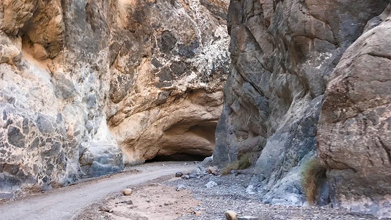
The Titus Canyon Narrows is less than 20 feet wide in some places.
The final 1.5 miles of Titus Canyon Road takes you into down into a narrow, twisted road flanked by near vertical cliffs of folded, twisted rock rising hundreds of feet on both sides. This is why the road is one-way! It is so narrow that the road is completely shaded and if you stop and shout, you’ll hear your voice echoing through the canyon.
We were amazed at once again being surrounded by a completely unique landscape, different from any other part of the drive and from any other hike we did in Death Valley National Park.
As we exited the Titus Canyon Narrows, we drove into a wide parking area with informational displays and vault toilets, the first one we had seen all day since visiting Rhyolite! Because the parking area is accessible from HWY 267, many Death Valley visitors who want to explore Titus Canyon but don’t want to do the entire 27 mile drive, park here and hike into the canyon.
Next, because we were already halfway there, we drove out to Ubehebe Crater before heading back to our hotel, The Ranch At Furnace Creek for a Thanksgiving dinner picnic.


Know Before You Go
- Titus Canyon Road is the most popular back country road in Death Valley National Park because in most weather it doesn’t require 4-wheel drive, but high clearance is recommended.
- The drive is 27 miles on a narrow, one-way dirt road that travels east to west. It starts two miles outside the park boundary near Rhyolite, Nevada off HWY 374 (Daylight Pass Road) and ends in Death Valley, California. The starting point is 6 miles from Beatty, Nevada and almost 25 miles from Furnace Creek.
- You’ll need to drive slowly and carefully! While the road is dirt, at times it is very rocky and uneven with deep pits and potholes. There are also tight hairpin turns on steep grades and sheer cliffs that drop hundreds of feet.
- The entire Titus Canyon Road drive takes an average of three hours, but it took us a little more than four hours because we stopped to climb on rocks, spot bighorn sheep, enjoy a tailgate lunch, explore Leadfield Ghost Town, and check out the petroglyphs at Klare Springs.
- The last three miles of the road is open to two-way traffic and at the west end of Titus Canyon, there is a parking area for those who don’t want to do the entire drive and only want to hike through the Titus Canyon Narrows.
- There are vault toilets in the parking area and these are the only restroom you’ll find along the entire Titus Canyon Road.
- The road is prone to flash flooding and often closed due to snow, mud, or wash outs. It is infrequently patrolled and summer travel is not advised.