Our family vacation and road trip through California’s Big Sur region remains one of my all time favorite family adventures.
Our vacation began in Hollister with two days hiking in Pinnacles National Park, exploring Balconies Cave and Bear Gulch Cave — which got our whole family completely hooked on caving. We then took a day trip to Monterey, visiting Cannery Row and Old Fisherman’s Wharf. The finale of our road trip and outdoor adventure was three unbelievable days in Big Sur.
- We visited several California State Parks like Pfeiffer Big Sur State Park, Julia Pfeiffer Burns State Park, and Limekiln State Park.
- We explored picnic grounds, vista points, and beaches like Sand Dollar Beach and Willow Creek Picnic Ground.
- We enjoyed delicious picnics, climbed high peaks, traversed rivers and creeks, and hiked to spectacular waterfalls like Limekiln Falls, Salmon Creek Falls, McWay Falls, Doud Creek Falls, and Pfeiffer Falls.
- To top it all off, we had the absolute most perfect weather we could have hoped for, which made driving Highway 1 through Big Sur an amazing experience.
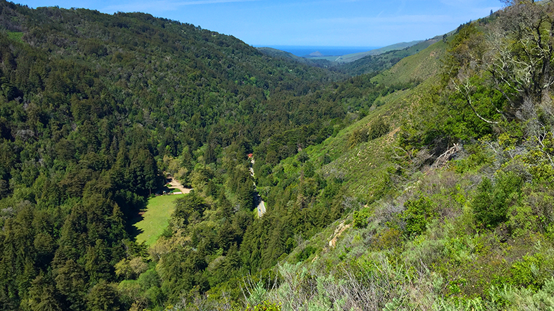
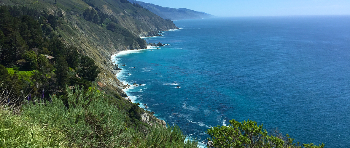
Just as one single stretch of road in Oregon, the Columbia River Highway, leads you past one incredible waterfall after another, California’s Highway 1 leads you past vista point after vista point with stunning views of the majestic, rocky Pacific coastline and beautiful Santa Lucia Mountains. Scattered up and down this gorgeous coastal road are state parks, beaches, picnic grounds, waterfalls, hiking trails, redwood groves, and campgrounds, as well as a few restaurants and hotels.
Driving Through Big Sur
The name Big Sur comes from original references to the unexplored coastal wilderness area south of Monterey as el pais grande del sur or the big south country. Today Big Sur is not a city, but a region. Big Sur encompasses the 90 mile stretch of coastline between Carmel and San Luis Obispo.
Highway 1, California’s first scenic highway and a designated American National Scenic Byway, winds along the Big Sur coast and through redwood forests in the Big Sur River Valley. It is flanked by the Santa Lucia Mountains on one side and the rugged Pacific coast on the other. If you’re taking a Highway 1 Road Trip along the Pacific Coast through Big Sur, be prepared for a slow and leisurely drive with A LOT of stops. This is easily one of the most beautiful stretches of road in the entire United States and you’re going to want to stop at all of the vista points and pull-outs for photos.
We began our Big Sur family vacation on the north end of the region at Garrapata State Park and worked our way south along the coast to the Elephant Seal Rookery. Below you’ll find our itinerary, with all of the awesome places we visited and explored, as well as a few notable bridges and key photo opportunities that I highly recommend you make time to check out.
Garrapata State Park
Nestled at the based of the Santa Lucia Mountain Range, Garrapata State Park is an unknown Big Sur treasure hiding in plain sight. Because there is only one small sign, no staff on-site, basically no facilities, and the trailheads are unmarked, many people simply drive right through the park and never even realize it.
Garrapata State Park is located on the northern end of the Big Sur coast, three miles south of Point Lobos State Natural Reserve. It has just under 3,000 acres of panoramic rocky shoreline, colorful wildflowers, jagged rock formations, steep chaparral-covered hills, deep redwood canyons, challenging hiking trails, and a breathtaking stretch of sandy beach.
Rocky Creek Bridge


Built in 1932, Rocky Creek Bridge is a 497 foot, reinforced concrete, open-spandrel arch bridge that spans Rocky Creek. It is located a few miles south of Carmel and just north of the more famous Bixby Creek Bridge on the Pacific Coast Highway — in fact, it is often mistaken for the Bixby Creek Bridge.
The scenic location of the Rocky Creek Bridge also marks two important habitat areas. The waters at the mouth of Rocky Creek are a habitat for the endangered southern sea otter, and above Rocky Creek the ridge line, sits one of the few known habitats of a rare orchid species called Yadon’s piperia.
There is a vista point northwest of the bridge with limited parking space. Be sure you pull over and check out the stunning views of the bridge and coastline.
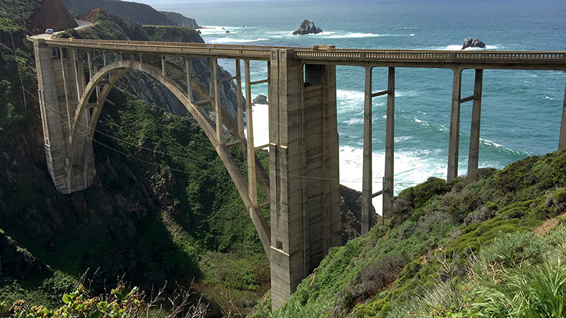
Bixby Creek Bridge


One of the tallest single-span concrete bridges in the world, Bixby Creek Bridge, also known as Bixby Bridge, is a 714 foot long, 279 foot tall, reinforced concrete, open-spandrel arch bridge that spans Bixby Creek. It is located on the Pacific Coast Highway, 120 miles south of San Francisco and 13 miles south of Carmel, in Monterey County.
When the State of California first began construction on the Highway in 1919, several bridges were needed, with the largest one spanning Bixby Creek. Before the Bixby Bridge was built, the only way to reach Big Sur was using a dirt road that turned inland for miles, and in the winter, was impassable. The Bixby Creek Bridge opened in 1932, connecting Big Sur with Montrey and Carmel. It substantially shortened and straightened the highway and provided year-round access for travelers.
Today the Bixby Creek Bridge is one of the most famous and most photographed features on the entire west coast of the United States. The bridge has been used in numerous car commercials, television shows, and marketing materials for the Big Sur region, and many Big Sur events.
While driving along Highway 1, it’s impossible to miss the grandeur of the Bixby Bridge or all of the cars parked along both sides of the highway and the people taking photos. Northeast of the bridge, there is a dirt road that turns inland. Be sure you make time to walk a little ways down the road to get a fantastic photo of the Bridge with the bright blue Pacific Ocean waters sparkling behind it.
Andrew Molera State Park
Andrew Molera State Park preserves nearly 5,000 acres of beautiful parkland at the north end of Big Sur. With magnificent sandy stretches, views of the brilliant blue Pacific Ocean, and trails through meadows and redwood forests, across coastal bluffs, and along the Big Sur River, this state park is still relatively undeveloped and offers visitors great hiking and a fairly deserted beach. The park has more than 20 miles of hiking trails, with trails that follow the shore, pass through grassy meadows, run along the Big Sur River, and climb to ridges with panoramic views of the gorgeous Big Sur coast.
Molera Beach is gorgeous. It is a pristine stretch of beach with sparkling sand, piles of driftwood, and crashing surf. On our hike to Molera Beach and Molera Point, just past the eucalyptus trees wind break, we discovered the Cooper Cabin, a Big Sur pioneer cabin built of hand-hewn redwood logs. While the cabin is not the oldest log building in the state of California, it is the oldest surviving log structure on California’s southern coast.
The Big Sur River Inn
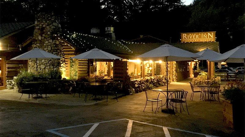
The Big Sur River Inn is truly an unforgettable, one-stop, family-friendly vacation destination nestled amid towering redwoods along the scenic Big Sur River. Originally named the Apple Pie Inn, the historic riverside lodge was Big Sur’s first hotel and restaurant and has been welcoming travelers since 1934.
There are 8 Riverside Suites in the main lodge building with king beds in the bedroom, trundle-style day beds in the living room, and decks overlooking the river, and 12 standard Motel Rooms in buildings on the opposite side of Highway 1, with one or two queen beds, and either porches or patios.
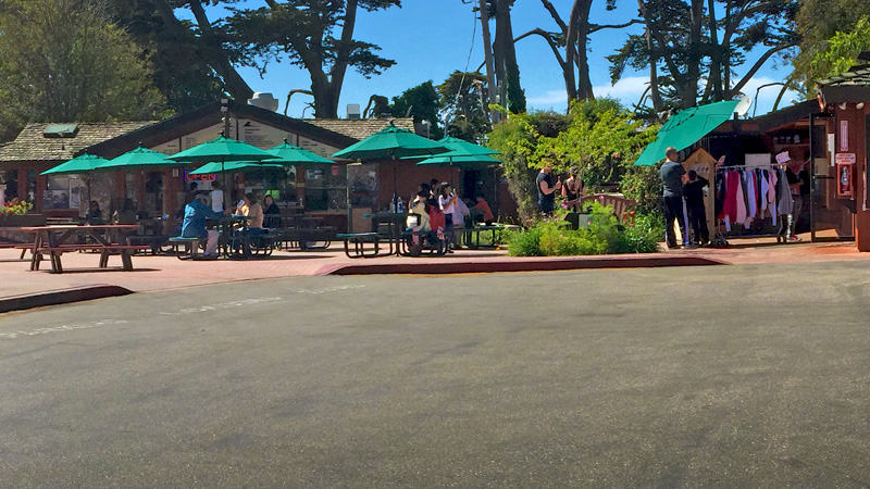
There is also The River Inn Restaurant, an ice cream bus, a gas station, and a store. We LOVED the General Store and the made-to-order burrito bar. With everything from camping supplies, sundries, donuts, and cold drinks, to a selection of beers and local wines, made-to-order pizzas and sandwiches, ice cream, fresh fruit smoothies, and a burrito bar, the General Store has everything you need for breakfast, lunch, and dinner, or a day of adventuring in Big Sur.
Pfeiffer Big Sur State Park
Sitting on the western slope of the Santa Lucia Mountains in the Los Padres National Forest, Pfeiffer Big Sur State Park has 1,006 acres of redwood, oak, sycamores, cottonwoods, maples, alders, chaparral, and open meadow areas. Its peaks tower high above the Big Sur River Gorge, where the Big Sur River enters the pristine park and flows past the spectacular 800-1,200 year old giant redwood trees that shade much of the park.
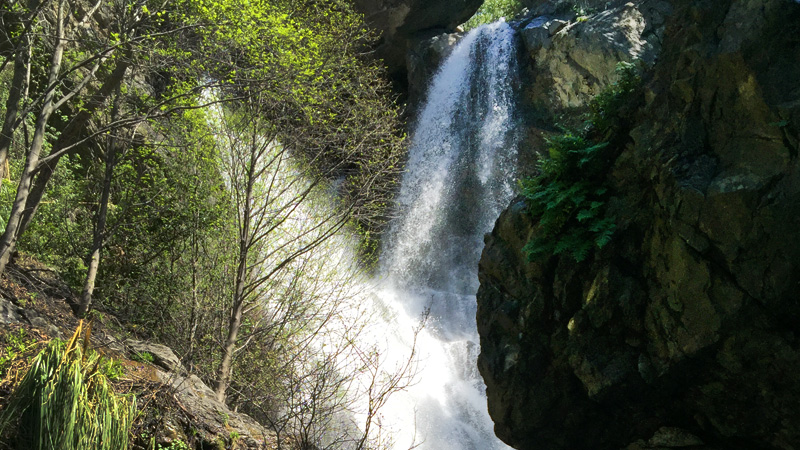
Next we did the Pfeiffer Falls Trail hike and the Valley View Trail hike. Both trails are the same for the first half mile, then they split apart. We combined both trails into one 2 mile, round trip hike to Pfeiffer Falls and the Valley View Overlook. We then followed the River Path and Warden’s Path, both wheelchair and stroller accessible along the Big Sur River, past oldest trees in the park on our way back to the Big Sur Lodge for ice cream.
Julia Pfeiffer Burns State Park
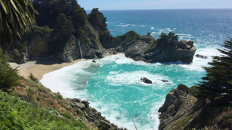
Julia Pfeiffer Burns State Park is a four-square-mile, 3,762 acre park in the Big Sur area of California that stretches from the rocky coastline into the 3,000 foot ridges of the Santa Lucia Mountains. With a majestic fairy tale like cove, an 80 foot waterfall plunging off vertical granite cliffs, and steep canyons filled with ancient, 2,500 year old, 300 foot redwood trees, this California state park is one of the most visited parks along the Pacific Coast Highway.
McWay Falls used to be a coastal waterfall or a tidefalls that emptied directly into the ocean, but in 1983 a massive fire and landslide just north of the park changed everything. Highway 1 was closed for almost a year for reconstruction and eight million cubic yards of dirt and rock were pushed into the ocean to stabilize the cliffs.
Over time, the ocean current carried the dirt from the landslide and construction south and created a beach at the foot of several coves along the shoreline, including McWay Falls. The waterfall now plunges not into the ocean, but onto the beach, and in certain times of day, into the tides.
Big Creek Bridge


Built in 1938, Big Creek Bridge is a 100 foot tall, 589 foot long, double-arch concrete bridge with half-arch side spans that crosses Big Creek Canyon. It is one of seven bridges constructed throughout Big Sur along the world famous Pacific Coast Highway.
There are roadside parking areas at both ends of Big Creek Bridge so you can stop and take photos, but the best view of the bridge is farther south down Highway 1. The highway curves to the right around the mountainside and there is a vista point on the coast-side of the highway that has a stunning view of the bridge and rocky Pacific coastline.
Landels-Hill Big Creek Reserve, part of the University of California Natural Reserve System, and two state marine protected areas, Big Creek State Marine Reserve and Big Creek State Conservation Area, are located next to the creek. The reserve and the beach below the bridge is closed to the public, but, one day each year it holds a Public Open House, and allows visitors to explore the trails and natural wonders.
Limekiln State Park
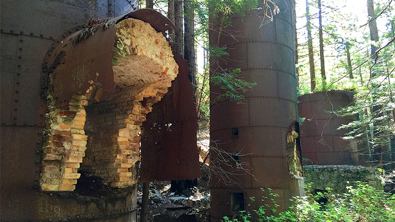
Adjoining the Ventana Wilderness area of the Los Padres National Forest, Limekiln State Park sits in steepest coastal canyon in the continental US, on the legendary Big Sur coastline, where the Santa Lucia Mountains meet the Pacific Ocean. The park’s more than 700 acres offer 24 campsites, three hiking trails, a redwood forest, a rocky beach, seascapes of the Monterey Bay National Marine Sanctuary, a breathtaking waterfall, and four enormous historic lime kilns.
The abandoned lime kilns are relics from the Rockland Lime and Lumber Company’s 1887-1890 limestone mining operations. The four huge furnaces were built at the base of the large talus slope that was eroding from a limestone deposit. Standing in the presence of these old, strong structures surrounded by plants and trees, away from the hustle of everyday life was simply amazing. It was like we had stepped back in time.
The Limekiln Falls Trail is a more challenging hike along the east fork of Limekiln Creek to a picturesque, 100 foot, fan-shaped waterfall cascading down a limestone wall. It will have you traversing the creek across tree-trunks and at times hiking through the creek water.
After hiking through Limekiln State Park, head down to the rocky Limekiln Beach to enjoy the sun, search for shells, and stick your feet in the water.
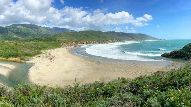
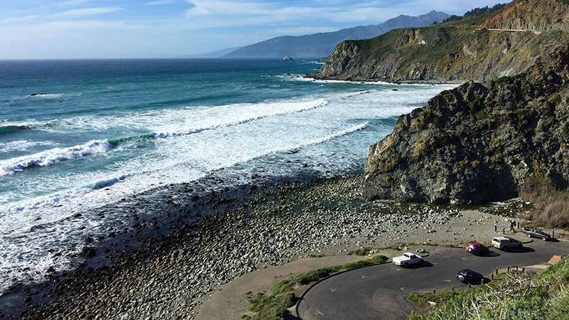
Sand Dollar Beach
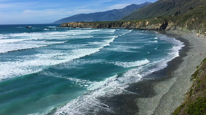
Sand Dollar Beach is one of the most popular beaches in Big Sur, California! It is not only one of just a few sandy beaches, but the longest, continuous stretch of beach in Big Sur.
Named for the flat sea urchins sometimes found on the beach, Sand Dollar Beach begins as a long pile of cobblestones and rocks and slowly turns into sandy beach as it reaches the water… or at least it does sometimes. At low tide, Sand Dollar Beach is a gorgeous sandy beach that stretches down the coastline and just begs to be walked on barefoot in the sun. At high tide, because the beach disappears and only piled rocks and cobblestones are visible, so you’ll probably be scratching your head confused, wondering if you’re even in the right spot.
The hike down the cliffs to the beach is a bit treacherous. The trail at first is an uneven dirt trail with switchbacks that must be navigated with care, as it is riddled with large potholes, ditches from some serious erosion. It ends at a steep, wooden staircase (about 100 steps) that descend to the beach.
Willow Creek Picnic Ground
Willow Creek Picnic Ground, Beach, and Vista Point is the last beach along the Big Sur coastline when driving from south from Monterey toward San Louis Obispo, and the first beach you encounter driving north on the Pacific Coast Highway.
With a majestic view of the rocky, sparkling, Big Sur pacific coast, the small parking area is the perfect spot to pull over, take a break, and enjoy the view — Cape San Martin and the San Martin Rock is visible to the south. Hidden from view at the vista point is the Willow Creek Picnic Ground. The day use area is accessed using a narrow road at the north end of the parking lot that leads down to the creek, some picnic tables, and Willow Creek Beach. There is parking for about more ten cars and some vault toilets (that smelled awful).
Salmon Creek Falls
Salmon Creek Falls is a 120 foot waterfall that cascades down a canyon in the Santa Lucia Mountain Range. This waterfall isn’t in a state park, it’s just on the side of the highway and a portion of of this Big Sur waterfall is visible from the highway… but it isn’t very clear about where the trail begins.
The Salmon Creek Trail begins about 3.5 miles north of Ragged Point on the inland side of the Pacific Coast Highway. You’ll know you’re in the right place when you find cars parked in a dirt pullout on the side of road of the most prominent hairpin turn on this stretch of the Pacific Coast Highway.
Ragged Point Inn And Plaza
Ragged Point offers one of the finest ocean vistas in the world, often called the Million Dollar View, where you can witness the majestic, awe-inspiring California coastline and sparkling blue waters of the Pacific Ocean. Towering high above the rocky Pacific coastline atop 350 foot sheer cliffs, the point boasts an art gallery, a gas station, a wedding facility, hiking trails, small shops, a public plaza with quick dining options, and of course, The Ragged Point Inn.
Piedras Blancas Elephant Seal Rookery
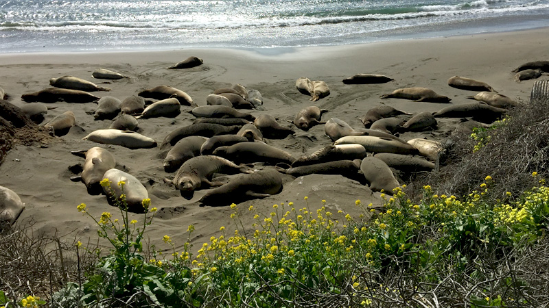
The Elephant Seal Rookery encompasses six miles of protected coastline where the elephant seals come for pupping and mating season, and to molt and grow new fur. This year alone 5,700 elephant seal babies were born along the coastline. To protect the elephant seals, a boardwalk and viewing areas are available with docents who can answer questions and tell you about the animals. Viewing areas are open every day and there are no fees or reservations required.
Know Before You Go
- If you’re planning a Highway 1 road trip through Big Sur, plan extra time to accommodate all of the scenic vista points and stops.
- When driving along Highway 1 in Big Sur, drive carefully and be diligent. Many drivers not only focused on the road, but on taking in the sights, and we saw several “almost-wrecks” and many close calls that could have been easily avoided. There are also lots of cars pulling in and out of vista point parking areas and roadside pull-outs, people walking along the highway taking photos, and inexperienced drivers going a little too fast in rented RVs.
- The summer months mark the busiest time of year in Big Sur with the most traffic. October through May is considered the off-season and the region is much less crowded, but you may have to deal with road closures and park closures due to rains and severer weather. In spring, the weather is cool, but it is typically sunny with clear skies and the coastal wildflowers are in bloom.
- When visiting Big Sur, dress in layers. Even when the sun is out, the weather can go from piping hot to almost freezing cold simply by stepping into and out of the sun or wind.
- Unlike beaches found in Southern California, most beaches in Big Sur are rocky and many require a hike to reach the beach. Be sure you have sturdy hiking shoes or tennis shoes with you.
- While there are many unforgettable places to visit along Highway 1 in Big Sur, don’t overlook the actual Highway! With several stunning and historic bridges, hairpin turns, and awe-inspiring views, just driving through Bgi Sur is an adventure of its own.
- There aren’t many gas stations in Big Sur, so it’s a good idea to fuel up and top off your tank before you need gas. Gas stations are located at The River Inn, Ripplewood Resort, Gorda Springs Resort, and Ragged Point.